Many of us have wondered, at some point of our lives, why the cartoons depicting the Earth as a watermelon with a missing portion always show this ball in the center named the 'core'. How do we know that a distinct 'body' is actually down there, 2900 km below the surface?
Let's see: we know the total mass of the Earth through its gravitational interaction with the solar system. In 1797, Cavendish[ref.1] measured the Gravitational constant G and the density of the Earth is ever since known to be about 5.51 times the density of water: nearly twice the average rock density we find at the surface.
2. Inge Lehmann was one of the key discoverers of the inner core of the Earth.
But only in 1906, Richard D. Oldham found that the increasing speed of seismic waves with depth within the Earth holds only down to 2890 km below the surface. Deeper than that, the mechanical (acoustic) waves propagate much slower (fig. 6), suggesting a different rock nature. Because this distinct material did not transmit shear seismic waves, it became clear that thiscore is liquid.
But in 1936, Inge Lehmann (picture on the right) found that the center of the core is indeed nearly-solid, since she inferred weak shear waves travelling through it [ref. 4] using highly-sensitive seismometers in New Zealand. This has become known as the inner core.
3. Images of the tsunami following last week's earthquake in Chile.
Today, detecting the core down there has become a doable task for anyone. Last week's earthquake in Chile, for example, provides a great opportunity for you to check if Oldham did everything right. You only need to get seismograms from seismic stations around the world (many of these stations have their data available online, real time), and sort the signals according to the distance from the station to the EQ's epicenter, using the same time of reference, like in this image:
4. Left: Each horizontal line is a seismogram of the Chile earthquake recorded at different locations of the planet (check USGS: 2015-10-16; Mw=8.3). Each seismogram is plotted according to the distance of the measuring station to the earthquake (vertical axis). The red circle shows the signal gap due to the outer core.
Right: Same image, with the identification of the arrivals of the different seismic waves. 'P' waves are the compressional waves, they are first to arrive all around the planet's surface.
The horizontal axis shows elapsed time, measured since the EQ occurred.
The vertical axis shows the distance from the measuring station to the EQ.
The red circle shows the region (around 110 degrees from the source) where the first seismic waves are not recorded.
5. Seismic shadow produced by an imaginary
earthquake occurring at the north pole. The
outer core, due to its slower seismic velocity,
refracts the mechanical waves of the earthquake,
shadowing a vast region of the planet, as seen
in figure 4.
6. The velocity of seismic waves
changes with depth within the Earth.
In summary: the absence of wave reception in regions around 14,000 km (between 103 and 143 degrees) apart from the hypocenter demonstrates that there is a liquid core where seismic waves travel slow.
Isn't it amazing that nobody realized this before the 20th century?
Finally, remember that the outer core is where the magnetic field of the Earth is generated, by the thermal convection of conductive molten iron around a nearly-solid iron inner core. In fact the changes in the convection patterns in the outer core seem responsible for the rapid historical changes observed in the magnetic field. There is more about the magnetic field in this earlier post.
7. Convection in the iron-dominated outer core around
a nearly solid core is widely accepted as the cause for the Earth's magnetic field, and known as the geodynamo. (Glatzmaier & Roberts).
Update 2015-12: Geophysicists call it the new core paradox: They can't quite explain how the ancient Earth could have sustained a magnetic field billions of years ago, as it was cooling from its fiery birth. Now, two scientists have proposed two different explanations. http://ow.ly/W3eQX
References (thank you nuclearplanet): 1. Cavendish, H., Experiments to determine the density of Earth. Philosophical Transactions of the Royal Society of London, 1798, 88, 469-479. 2. Wiechert, E., Über die Massenverteilung im Inneren der Erde. Nachr. K. Ges. Wiss. Goettingen, Math-Kl., 1897, 221-243. 3. Oldham, R. D., The constitution of the interior of the Earth as revealed by earthquakes. Q. T. Geol. Soc. Lond., 1906. 62, 459-486. 4. Lehmann, I., P'. Publ. Int. Geod. Geophys. Union, Assoc. Seismol., Ser. A, Trav. Sci., 1936, 14, 87-115.
Out of this age of crisis, a book has just been published that aims at fully opening the doors of imagination to show how audacious we humans are when in need to restart from scratch:
The book includes an article by the editor Ricarda Vidal (King’s College London) giving an updated perspective on the Atlantropa Project(1929). Atlantropa intended to reduce the area of the Mediterranean Sea by 30% by damming the Strait of Gibraltar, allowing natural evaporation to lower the sea level by a couple of hundred meters. With this project, Herman Sörgel sought to control the inflow of Atlantic seawater to generate electricity, to exposing new inhabitable land (former submarine continental shelf), and to use the Nile River to irrigate a vast part of the Sahara Desert.
The project thus aimed at mimicking what nature did 6 million years ago during the Messinian Salinity Crisis, and that's why I coauthor with Vidal a second chapter dealing with what we know about this ancient salinization and desiccation of the Mediterranean from a scientific perspective, and about the footprint this geology left in western culture.
The rest of the volume discusses fascinating Alternative Worlds including seasteads, planned cities, the high-rise age, and the promising worlds-to-be in the outer space.
Part I: Shaping the Earth and Sea
1. Ricarda Vidal: Atlantropa: One of the Missed Opportunities of the Future
2. Daniel Garcia-Castellanos/Ricarda Vidal: Alternative Mediterraneans Six Million Years Ago: A Model for the Future?
3. Philip E. Steinberg/Elizabeth A. Nyman/Mauro J. Caraccioli: Atlas Swam: Freedom, Capital and Floating Sovereignties in the Seasteading Vision
Part II: The 1960s – Building the Future
4. Patricia Silva McNeill: The Last ‘City of the Future’: Brasília and its Representation in Literature and Film
5. Elena Solomides: The Post-War High-Rise: Promise of an Alternative World
6. Christopher Daley: ‘The landscape is coded’: Visual Culture and the Alternative Worlds of J.G. Ballard’s Early Fiction
Part II: Alternative Lives
7. Maya Oppenheimer: Designed Surfaces and the Utopics of Rejuvenation
8. Boukje Cnossen: The Alternative World of Michel Houellebecq
9. Susanne Kord: From the American Myth to the American Dream: Alternative Worlds in Recent Hollywood Westerns
10. Marjolaine Ryley: Growing up in the New Age: A Journey into Wonderland?
Part IV: Outer Space
11. Peter Dickens: Alternative Worlds in the Cosmos
12. Ingo Cornils: Between Bauhaus and Bügeleisen: The Iconic Style of Raumpatrouille (1966)
13. Rachel Steward: Blue Sky Thinking in a Post-Astronautic Present.
Alternative Worlds, Blue-Sky thinking since 1900, R. Vidal & Cornils (Peter Lang Publishing, Bern, ISSN 3034317875, 9783034317870).
R.B. Cathcart, "What if We Lowered the Mediterranean Sea?", Speculations in Science and Technology, 8: 7-15 (1985).
[Este post está orientado a estudiantes que comienzan una carrera universitaria en ciencias, no necesariamente geología]
El Mar Mediterráneo es lo que resta en la actualidad del antiguo Océano de Tethys, que quedó atrapado entre las placas tectónicas de África y Eurasia durante su lenta aproximación en los últimos 65 millones de años. A causa de esta aproximación,la corteza terrestre oceánica que alojaba al Océano de Tethys fue obligada a hundirse (a subducir) en el manto terrestre, bajo Eurasia, tras lo cual se produjo la colisión entre ambos continentes, formando los Pirineos, los Alpes y las Montañas de Zagros (orogenia Alpina). Fue así como quedaron desconectados el actual Mar Mediterráneo y el Océano Índico hace unos 15 millones de años. Sólo en el Mediterráneo Oriental quedan restos de aquella corteza de Tethys que aún no han subducido y que de hecho constituyen la corteza oceánica más antigua preservada en el planeta: unos 270 millones de años de edad. Puedes descargar este espectacular KML para Google Earth y visualizar la edad de formación de la corteza terrestre.
Fig. 1. Movimiento de las placas tectónicas deducido principalmente a partir del campo magnético grabado en las rocas (técnica conocida como paleomagnetismo) y de la geología y paleontología observadas en superficie.
Fig. 2. Movimiento de rotación de África respecto a Eurasia en los últimos 190 Millones de años. A partir de medidas de paleomagnetismo en rocas. Vía MantlePlumes.org
Es sorprendente encontrar la corteza oceánica más antigua del planeta en el Mediterráneo, pues el acercamiento entre Europa y África continúa hoy a un ritmo geológicamente rápido, de unos 4 milímetros por año en la región más occidental (entre España y Marruecos), y a velocidades aún mayores y con mayor actividad sísmica en Grecia o Turquía.
Fig. 3. Movimiento relativo de Anatolia y el este del Mediterráneo respecto a Eurasia, obtenido a partir de medidas de GPS de alta precisión. La longitud de las flechas indica la velocidadactual debido a la tectónica medida en una estación de GPS. Las mayores corresponden a 4 cm/año.
Fig. 4. Modelo de la velocidad tectónica en el Mediterráneo (flechas
relativas a Eurasia) y de las tasas de deformación que implican.
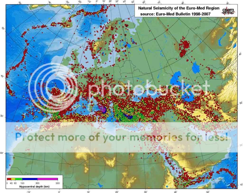
Pero el Mar Mediterráneo ha tenido una evolución tectónica más compleja que la simple subducción de África bajo Eurasia, como reflejan la heterogénea distribución de los terremotos (Fig. 5) y los varios dominios o subplacas cuyos movimientos tectónicos responden de manera poco intuitiva al acercamiento entre los dos continentes (Fig. 6b).
Fig. 5. Distribución de terremotos y su profundidad en el área mediterránea.
Como consecuencia de la geometría heredada de ambos continentes, se han formado varias zonas de subducción diferenciadas (Fig. 6b) en las que la corteza oceánica de Tethys es cabalgada por los márgenes del sur de Europa antes de sumergirse en el manto terrestre. Un ejemplo es la subducción que se produce en el Arco de Calabria (Sicilia y sur de Italia), donde la placa Africana subduce bajo el Mar Tirreno, dando origen a una importante actividad sísmica y volcánica (Etna, Stromboli, etc, Fig. 6c).
Fig. 6a. Esquema del proceso de subducción
de las placas tectónicas oceánicas.
Fig. 6c. Hundimiento y retroceso del slab
(de la porción de placa tectónica subducida)
de Tethys dando lugar a la formación por
extensión de la corteza del Mar Mediterráneo
(Mar Tirreno en la imagen). África a la derecha; Europa a la Izda. De Faccenna et al., GJI, 2001)
Fig. 6b. Mapa tectónico simplificado del Mediterráneo actual, mostrando la edad de formación de la nueva corteza oceánica (azul, de hasta 25 millones de años) tras la subducción del Tethys en la parte occidental. Las zonas mucho más antiguas de corteza oceánica en la zona oriental (morado) corresponden a la placa del antiguo océano de Tethys. Las líneas dentadas rojas indican las fosas donde esa placa se adentra en el manto (subduce) bajo Europa.
Para entender la formación del Mediterráneo es clave comprender un proceso llamado extensión de tras-arco (back-arc extension), que es el estiramiento o extensión de la corteza terrestre que ocurre detrás de una zona de subducción, encima del slab subducido (a la izda. en el corte de la Fig. 6c). Debido a la mayor densidad de la placa de Tethys, ésta se hundió en el manto succionando y estirando la placa bajo la cual subducía (Europa). A consecuencia de esa dinámica (Fig. 7) se separaron del continente europeo las islas de Córcega, Cerdeña y Baleares.Otro ejemplo más lejano del mismo proceso es la separación que actualmente se produce entre Japón y Asia, debida a la subducción de la placa Pacífica bajo la fosa donde se originó el terremoto de Sendai.
Fig. 7. Izda.: la extensión de tras-arco es un estiramiento de la corteza que se produce encima de los slabs subducidos. Vídeo: Simulación de la extensión de tras-arco (back-arc extension) debida al hundimiento y la retirada de una placa tectónica (slab retreat orslab rollback), modelo de Moresi y coautores. Si el lado izquierdo fuera África y el derecho Europa (al revés en el esquema de la izda.), entonces la extensión que se produce en el centro correspondería al Mediterráneo.
Fig. 8. Reconstrucción de la retirada del slab (slab retreat) que da lugar a la extensión del Mar Tirreno y del Golfo de Valencia, separando las islas Baleares de la Península Ibérica, hace unos 25 millones de años. Las líneas discontinuas indican la posición de la subducción hace 30 y 16 millones de años. Las flechas negras indican también el mismo proceso ocurrido en el arco helénico (Grecia) y en la Cuenca Panónica (Hungría/Rumanía).
En resumen: hoy el Mediterráneo occidental ocupa una enorme cuenca extensiva de tras-arco desgarrada tras la subducción de la corteza oceánica de Tethys bajo el continente europeo y la posterior colisión continental entre África y Eurasia. Esta es al menos la visión más generalizada hoy entre los geólogos.
I've been trying to learn a bit more about comets (call it summer-research) taking the chance of the visit of the ESA Rosetta mission to comet 67P (aka Churyumov–Gerasimenko).
Comets are small bodies of rock and ice thought to form in the outer regions of the solar system at the same time planets were formed, ca. 4.6 billion years ago. An important known unknown about comets is their relative contribution to the accumulation of water in the early Earth. So learning about them is learning about our planet too.
67P is a 4 km-long ice body orbiting around the sun every 6 years, following an elliptical orbit ranging between those of the Earth and Jupiter.
Barcelona and 67P, to scale
The shape of 67P suggests that it might be the result of the accretion of smaller comets. In fact, one thing that surprises many of us who are unfamiliar with comets is their low density. Most of the comet you see in these pictures has been left empty during its formation. 67P is about 10 2.5 times lighter than water: 102 400 kg/m3 (figures updated after Rosetta's approach), implying that it is a very porous body. Is this related to an accretion process?
Image taken on 2014-08-12 from a distance of 103 km. Credit: ESA/Rosetta/NAVCAM
Another curious fact: 67P used to have a perihelion distance of 2.7 AU (1 AU = distance from the Sun to the Earth), but in February 1959 an approach to Jupiter reduced this to only 1.3 AU, where it remains today. Comets are often shifted by the gravity field of planets, but recent events like this remind us that we are not in a static Solar System. The same process can lead to the split of comets in pieces: a beautiful example is given by the comets 42P/Neujmin and 53P/Van Biesbroeck, which appear to be fragments of a parent comet. This is based on computer integration, a reconstruction of their past position, showing that both comets were close to Jupiter in January 1850 and had nearly identical orbits before that. The debris produced by such comet disintegrations is often responsible for meteor showers like the Perseids seen worldwide in middle August.
Approach to a distance of 104 km. 67P rotates once every 12.7 hours. Credit: ESA/Rosetta/NAVCAM
Rosetta's won't be the first mission actually touching down on a comet (check this list of space missions that have approached comets, and see the unsubtle 'landing' of Deep Impact in the animation below). But it is the first mission ever to smoothly land on a comet (Philae lander) and to analyze its surface. And it is the first mission to orbit a comet, something remarkable since the escape velocity of 67P is only 0.5 m/s. It will also be the first mission to land a probe on the surface and, in the words of ESA, Rosetta will be "the first spacecraft to fly alongside a comet as it heads towards the inner Solar System, watching how a frozen comet is transformed by the warmth of the Sun". A lander will sample the composition and structure of the comet nucleus, drilling more than 20 cm into the subsurface for analysis at the onboard laboratory.
Rosetta has costed the europeans around 1 billion euros (10^9 €) through a consortium of the German Aerospace Research Institute (DLR) with ESA, CNES, and european and american research institutes. The results will provide information on how comets form and also on the early stages of the Solar System. It should contribute to the discussion on where did the terrestrial water form and when did it arrive here. Previous studies have shown that the isotope ratios of hydrogen in other comets is different from that of oceanic water, but it remains unclear that these comets were representative enough of the comet orbits most likely to contribute to our waters. New answers will arrive soon, together with new questions.
Let me tell a story about serendipity in research, a story that involves abrupt changes in the Earth's landscape and a 5-million-year-old flood of unprecedented scale.
Classical authors such as Aristotle, Galileo, or Leonardo da Vinci, used to describe the birth of the Mediterranean Sea as an enormous flood through the Strait of Gibraltar that filled a desiccated basin. These stories trace back to the oldest known encyclopedia: Plinius' Historia Naturalis (1st century AD). In its 3rd volume, Plinius the Elder recounted a legend from southern Hispania that attributed the formation of the Strait of Gibraltar to Hercules, the god who "allowed the entrance of the ocean where it was before excluded". The Atlantic Ocean flooding a desertic Mediterranean Sea at epic scales. Amazingly enough, the geophysical and geological research carried out in the last decades seems to suggest that this ancient vision may be quite appropriate.
Since the identification of vast salt strata throughout the Mediterranean by Austrian naturalist Karl Mayer (late nineteenth century) we know that the marine connections between this sea and the Atlantic Ocean became small by the end of the Miocene, during a period known as the Messinian age. Modern chronostratigraphy has dated this at 6 to 5.3 million years ago, around the time when our earliest hominin ancestors started walking on two legs in Central Africa. As a result, the Mediterranean became a huge salt pan that accumulated about 10% of the salt dissolved in the world's oceans, during the so-called Messinian salinity crisis. The ongoing tectonic uplift of the Gibraltar Arc region finally emerged the last Atlantic seaway and isolated completely the Mediterranean from the ocean, about 5.6 million years ago. The Mediterranean then became largely evaporated as a result of the dry climate of its watershed. Finally, about 5.3 million years ago the Mediterranean was refilled from the Atlantic through the Strait of Gibraltar. The indications that this occurred geologically very fast (namely, the abrupt change from Miocene to Pliocene sedimentary layers) made this event be known as theZanclean flood.
Simulation of the refill through the strait of Gibraltar
by Steven N. Ward (Univ. California).
Note the water velocity distribution around 1:27.
Geological map of the Gibraltar strait locating the
erosion channel (red) observed with geophysical
methods.
The flood along the Gibraltar threshold may have been caused by its subsidence below the Atlantic level, or by faulting, or by erosion (or a combination of these three proposed mechanisms). But beyond the causes for the flood, another key unknown is the abruptness and evolution of the flood itself: From the sharp transition in the sedimentary layer record, it is widely thought (though not unanimously) that the event was very fast. But in geology fast can mean a hundred thousand years. Because little was known about its dynamics, and perhaps because for geologists rapid major events are rare and challenge the principle of uniformitarianism, the flood duration underwent a wide range of estimations from tens to tens of thousands of years.
Before knowing anything about the Messinian Mediterranean, I used to model the evolution of landscape over geological time scales, particularly interested on the role of lakes in controlling the long-term evolution of topography of large continental regions.
Lakes are those water bodies collecting precipitation in local topographic minima (yes, this sounds a bit Sheldon-like). Lakes are usually ephemeral over geologic timescales: Unless there are vertical tectonic motions enlarging the topographic basin, they soon fill up with sediment, overspilling their banks. When the water finds a way out, it incises along the outlet, drawing the lake's level down, and propagating this erosion upstream into the lake. In our landscape evolution models this transition was systematically very fast, but this result was not convincing enough for two reasons: First, lake data to compare with were scarce, and we were in the need of a large case scenario where traces of erosion were more evident. Secondly, our models where not accounting for transitory water flow, but instead it was calculating a steady flow (i.e., the water precipitation equals the water losses through evaporation at each time step of the simulation).
2D simulation of the evolution of a tectonic lake
formed in front of a growing tectonic barrier.
The lake evaporates the water collected from
the left side. When the barrier stops growing,
its erosion leads to a sudden capture of the lake.
Then I accidentally learned about the Messinian salinity crisis, about its impact in the Mediterranean evolution, and about the megaflood hypothesis for its ending. It struck me that the feedback between water flow and incision we envisaged for lakes should be similar during the Zanclean flood, taking the global ocean as a huge lake on the verge of overtopping towards the dry Mediterranean. Combining the formulation of river incision with the proper hydrodynamic equations, we built a simple but robust mathematical formulation for overtopping outburst floods. We used then erosional parameters derived from the study or mountain river incision, and then incorporated a reconstruction for the Mediterranean seafloor geometry. Then we started running virtual floods.
The first results were so surprising that we thought something was probably wrong with the code. Things were happening much faster than in those lake scenarios we were used to. Because in the Zanclean flood the source is virtually infinite, the Mediterranean was filling in only a few years along a large erosion channel excavated across the Strait of Gibraltar, some hundred meters deep. Unfortunately, the results were strongly dependent on a parameter that is badly constrained: the erodibility of rocks. But if that was correct, we should be able to find traces of the flood erosion preserved under the sedimentary layers in the strait.
Dry Mediterranean, by Roger Pibernat.
So we turned towards previously published research, finding two other pieces of evidence: The first was a vintage seismic image showing a cross-section of the sedimentary layers near the strait area (Campillo et al., 1992). It showed a clear channel running west to east from the strait into the Alborán Sea, carved in the pre-Messinian sediments. The channel had previously been thought to be the result of river erosion of the dried-up strait, but there’s no obvious large river that could have produced that erosion. The second piece of evidence came from cores of rock drilled from the strait area as part of the exploration for the Africa-Europe tunnel project that would build a train connection between Spain and Morocco (Blanc, 2002). These cores also showed a channel deeper than 200 m, wider than 3 km, and filled with post-Messinian sediment. Altogether, the documented erosion valley connecting the Eastern Atlantic to the Western Mediterranean is more than 200-kilometre long. If this were a result of fluvial erosion, it would be strange to find erosion on both sides of the present water divide between Atlantic and Mediterranean. Furthermore, rather than a waterfall over the Gibraltar Strait as previously suggested, the seismic data show a huge ramp, several kilometres wide descending rather gradually from the Atlantic to the Mediterranean.
With these data, we turned again to the models. Using the observed erosion depth and width as a constrain, the model estimated now that the flood may have began slowly, taking up to several thousand years before a significant rise in Mediterranean level occurred. But importantly they also show that 90% of the water must have entered in a period shorter than two years, and that at the peak discharge, water poured in at a rate of 100 million cubic meters per second, about a thousand times the largest river on Earth today. If 'harder' erosion parameters were used, then the refill of the Mediterranean would be predicted to be slower, but the calculated erosion at the end of the flood would be insufficient to reproduce the geophysical images. To fit the observations, the flooding channel had to cut down into the bedrock almost half a meter per day, leading to a large inlet flow that would increase the Mediterranean sea level by more than 10 meters per day.
The technique does not allow constraining the speed of the initial stages, nor the mechanisms involved in triggering the flood. This means that the initial trigger may have been a geologically modest event such a large storm, a tsunami, or a partial collapse of the dividing barrier. What the results do ensure is that in order to account for the final size of the erosion channel, 90% of the water must have been rapidly transferred in a period ranging from a few months to two years.
Possible evolution of the flood derived from the model. The lower panel shows the evolution of the seaway depth as it is eroded by the increasing flow of water (black lines, left scale) and the rising Mediterranean level (red lines). From our article in Nature.
If these observations and calculations are independently confirmed, the Zanclean flood would become the largest known flood on Earth's history. The Zanclean flood involved an order of magnitude more water flow than the megafloods that we know took place during the last deglaciation (e.g., the Missoula floods or the Bonneville flood).
The implications of such a rapid flooding are inevitably big, as a large number of multidisciplinary studies have documented: Global flora and fauna had to adapt to the new
environmental conditions rapidly. Marine species colonized a huge new realm rapidly whereas for land species, particularly in islands, the flooded
Mediterranean became a sudden barrier triggering speciation. Had the land connection remained, it could have facilitated an earlier arrival of early humans in western
Europe. Instead early humans had to take a circuitous route to Western
Europe and didn't arrive until 1.5 million years ago. The Messinian salinity crisis also highlights the importance of seaways in understanding the geological record: straits limit the mix with the global ocean and their size is the key parameter modulating the chemical registry found in sediment. The flood may also have had tectonic implications: The weight of the flooding waters is such that it should have modified the rotation of the Earth, and it should have made the entire Mediterranean region sink by at least one kilometer in the mantle, according to the principle of Isostasy. Also global climate surely must have been impacted by the Messinian salinity crisis and its rapid ending, but so far this is perhaps the most elusive aspect of the crisis, something remarkable since I am not aware of other scenarios in geological history where the climatic response to such a large environmental change can be better tested.
So there are plenty of open questions on the Zanclean Flood that need an answer. More pending Retos Terrícolas.
Video on the Atlantropa Project, showing the collapse of a
projected dam across the Strait of Gibraltar.
[This is related to research of our own group here at CSIC, as published inthis article]
[This post has been published in Mapping Ignorance]
References:
Blanc, P.-L. The opening of the Plio-Quaternary Gibraltar Strait: assessing the size of a cataclysm, Geodin. Acta 15, 303—317 (2002).
Campillo, A., Maldonado, A. & Mauffret, A., Stratigraphic and tectonic evolution of the western Alboran sea: Late Miocene to recent, Geo Mar. Lett., 12, 165– 172 (1992).
Garcia-Castellanos, D., 2006. Long-term evolution of tectonic lakes: Climatic controls on the development of internally drained basins. In: Tectonics, Climate, and Landscape evolution. Eds.: S.D. Willett, N. Hovius, M.T. Brandon & D.M. Fisher. GSA Special Paper 398. 283-294. doi:10.1130/2006.2398(17) [pdf]
Garcia-Castellanos, D., F. Estrada, I. Jiménez-Munt, C. Gorini, M. Fernàndez, J. Vergés, R. De Vicente, 2009. Catastrophic flood of the Mediterranean after the Messinian salinity crisis. Nature 462, 778-781 doi:10.1038/nature08555 [pdf]