How much does the erosion and sedimentation at the Earth’s surface influence on the patterns and distribution of tectonic deformation? This question has been mainly addressed from a computer modelling perspective, at scales ranging from local to orogenic. In the PLOS ONE paper published today, we present a model that aims at understanding this phenomenon at the continental scale, looking at the feedbacks between continental enlargement and climate aridification during the collision of continents.
60-million-year indentation of a continent from the south
(at 50 mm/yr).
Left: Topography and areas with precipitation higher than 400 mm/yr (red shading). Note the
orographic rainfall developing at the southern flank
of the growing plateau. Wind blows from the southeast
(towards the upper left corner).
Right: erosion and sedimentation rates, and contours of crustal thickening rate due to tectonics.
By Garcia-Castellanos & Jimenez-Munt, PLOS ONE, 2015.
We couple a thin-sheet viscous model of continental deformation with a stream-power surface transport model. The model also incorporates flexural isostatic compensation that permits the formation of large sedimentary basins and a precipitation model that reproduces basic climatic effects such as continentality and orographic rainfall and rain shadow. We calculate the feedbacks between these four processes acting at different scales in a synthetic scenario inspired and scaled by the India-Asia collision. The model reproduces first-order characteristics of the growth of the Tibetan Plateau as a result of the Indian indentation.
Note that the southern continent (the indenter, India) is chosen fixed to our reference frame, whereas the northern continent (Asia) is moving southwards).
The initial topography is flat with small random noise forming a network of lakes. The tectonic indenter in the southern boundary represents India, while a rigid block fixed around x=2500km represents the Tarim Basin.
Wind blowing from SE at 7 m/s (relative humidity=1). Red shading indicates orographic precipitation.
The continental deformation adopts a thin-sheet tectonic model. + info here.
What these simulations show is that, at large space and temporal scales, the climate dryness that develops in continental interiors triggers the trapping of sediment in closed basins within the continent, instead of exporting it to the continental margins. In the left panel you can see a large intramountain basin (comparable to the Tarim Basin) developing within Asia when a hard lithospheric region in predefined within the continent. The amount of sediment trapped in it is very sensitive to climatic parameters, particularly to evaporation, because it crucially determines its endorheic/exorheic drainage. We identify a feedback between erosion and crustal thickening leading locally to a <50 at="" climatically-enhanced="" concentrated.="" corners="" deformation="" flank="" growing="" in="" increase="" indenter="" is="" of="" orographic="" p="" place="" places="" plateau="" precipitation="" preferentially="" rates="" specially="" syntaxes="" takes="" the="" this="" upwind="" where="">
We hypothesize that this may provide clues for better understanding the mechanisms underlying the intriguing tectonic aneurysms documented in the Himalayas. At the continental scale, however, the overall distribution of topographic basins and ranges
seems insensitive to climatic factors, despite these do have important, sometimes counterintuitive effects on the amount of sediments trapped within the continent. The dry climatic conditions that naturally develop in the interior of the continent, for example, trigger large intra-continental sediment trapping at basins similar to the Tarim Basin because they determine its endorheic/exorheic drainage. These complex climatic-drainage-
tectonic interactions make the development of steady-state topography at the continental scale unlikely.
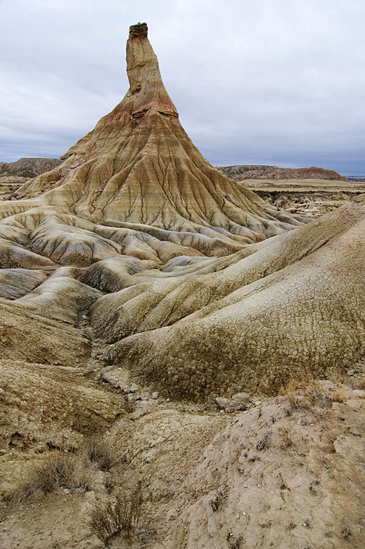
The previous post dealt with the erosion of the Ebro Basin after its colmatation with sediment, about 10 million years ago. The journal Geology has just chosen the following picture to illustrate the cover of their August volume:
Castildetierra is one of the many hills sculpted by erosion of the ancient sediment infill of the Ebro Basin at Bardenas Reales (Navarra, Spain). Photo: Larrión & Pimoulier. Location: 42.2103 N, 1.5157 W
The soft alluvial clays that make most of this hill are interbedded with harder lacustrine limestones and fluvial sandstones. The same alternation prevails over much of the Ebro Basin (NE Spain). These strata record a 19-million-year-old lake and alluvial system in the centre of an endorheic Ebro basin (84,000 km2 in area). Subsequent basin capture and drainage integration towards the Mediterranean lead to erosional features like the one in the picture.
Despite the most recent sedimentary has been removed by erosion, our study could date this major drainage change at 12.0-7.5 million years ago, based on isostatic modeling constrained with paleomagnetic data. In these badlands at Bardenas Reales (Navarra), high erosion rates have been measured in the order of millimeters per year, but how these rates link to the long-term history of the region is unclear. Other places in the basin show Pleistocene erosion rates in the order of 0.1-0.4 mm/yr, whereas our results suggest an average erosion rate since the Miocene of 0.05-0.1 mm/yr.
Summary of the scientific article in Geology: Basins formed within mountainous regions often become perfect sedimentary traps that do not drain to the sea but to internal evaporitic lakes. When they do, their sediment layers ideally record the climatic, topographic, and tectonic history of the surroundings. And when these basins eventually overtop or overfill with sediment, they are rapidly excavated by the new outflowing fluvial network, exposing excellent stratigraphic outcrops. However, this erosion often removes the uppermost basin infill, and essential information about the late basin history is lost. We have estimated the timing and elevation of the maximum infill of the Ebro basin (NE Spain) by computing the rebound of the basin in response to erosion, adopting the common idea that the Earth's rigid outer shell (the lithosphere) rests on a fluid magmatic asthenosphere in an Archimedes-type equilibrium (isostasy). We combine these calculations with existing paleomagnetic ages of the sediment basin infill. The results show that the basin became overfilled between 12 and 7.5 million years ago, and that it reached a maximum elevation of up to 750 m above present sea level. The basin has been ever since incised at a rate close to 0.1 mm/yr and has been isostatically uplifted by up to 630 m at its center. This uplift may explain why the Ebro River, opposite to other large Mediterranean rivers, does not present a deep gorge excavated within its own basin during the desiccation of the Mediterranean (Messinian salinity crisis, 5.5 million years ago).
Viajando entre Navarra y Lleida habrás reparado seguramente en las capas casi horizontales de sedimento, omnipresentes en la Cuenca del Ebro. Se trata de sedimento depositado en el fondo de lagos y en ríos durante el Mioceno (hace entre 24 y 5 millones de años), proveniente de la erosión del Pirineo y, en menor medida, del Sistema Ibérico y la Cordillera Costero-Catalana.
1. Vista desde la cima de San Caprasio (Zaragoza), en el centro de la Cuenca del Ebro (cubierta por las nubes). A la derecha aparecen los sedimentos calcáreos más modernos preservados en la cuenca, datados en 13.6 millones de años. Foto: DGC.
2. Bardenas Reales (Navarra). Foto: PN Bardenas.
3. La roca calcárea en lo alto del Cabezo de Castildetierra (Bardenas Reales, Navarra) apenas protege a las margas de la erosión. Esas calizas se formaron en los lagos que ocupaban la Cuenca del Ebro hace entre 36 y 10 millones de años. Foto: Carlos Sancho
Ese sedimento contiene importantes cantidades de yeso recristalizado (CaSO4·2H2O, Imagen 4), proveniente de la disolución de yesos más antiguos en el Pirineo. La acumulación de estas rocas evaporíticas indica que ese antiguo sistema de lagos del centro de la cuenca carecía de desaguadero, es decir, era un sistema endorreico en el que todo el agua recogida acababa siendo evaporada.
4. Yeso cristalizado visible en los niveles intermedios de San
Caprasio. Unos 18 millones de años de edad. Foto: DGC
Tras ese largo periodo endorreico, el sistema lacustre rebosó o resultó colmatado de sedimento, formándose el actual río Ebro, que ha erosionado y transportado al delta más de 30,000 km3 del antiguo relleno de la Cuenca del Ebro. Hoy, el sedimento preservado más elevado está precisamente en la zona central de la misma, en la Sierra de Alcubierre, 20 km al este de Zaragoza y a 840 m sobre el nivel del mar (Imagen 1).
¿Porqué están más altos esos sedimentos en el centro de la cuenca, si los lagos deberían ocupar la zona topográficamente más baja? ¿Y porqué no rebosaron antes los lagos hacia el Mediterráneo, si la actual divisoria de la cordillera Costero-Catalana tiene lugares de menos de 500 m de altitud?
En ausencia de deformación tectónica (las cadenas montañosas circundantes ya se habían acabado de formar), los movimientos verticales de la superficie de la Tierra están generalmente relacionados con la isostasia: La erosión de la cuenca del Ebro supuso una descarga y un levantamiento (un rebote isostático) de la litosfera terrestre, que descansa sobre el manto como si se tratara de un iceberg en el océano.
5. Hundimiento isostático que sufre la litosfera (en gris) sobre la
astenosfera fluida (blanco) cuando sobre ella descansa una carga (verde),
para 4 escenarios en los que la litosfera es progresivamente más delgada y débil.
En el escenario de una litosfera muy gruesa y rígida no se producen movimientos verticales
de reajuste. En el caso más débil, cada columna del sistema se reajusta localmente y
tiene el mismo peso si se mide hasta un nivel de compensación en la astenosfera. Autor: DGC
En nuestro artículo de esta semana, hemos calculado estos movimientos verticales de la litosfera terrestre para poder estimar el volumen de sedimento erosionado que falta en la cuenca del Ebro. Comparándolo con el volumen actualmente acumulado en el delta del Ebro, hemos podido establecer la edad en la que se produjo la colmatación, el relleno máximo de la cuenca, entre 7.5 y 12.0 millones de años, así como la altitud original que alcanzó la cuenca: 535–750 m sobre el nivel actual del mar.
6. Animation (reload page if necessary): Estimated topographic evolution of the Ebro Basin (NE, Spain) since 10 million years ago until present
7. Las cuencas endorreicas (zonas que no drenan sus aguas al mar) suelen presentar sistemas lacustres que son extremadamente sensibles a las variaciones climáticas, pues en ellos la superficie lacustre se debe adaptar para compensar la lluvia recogida con la evaporación en su superficie.
Let me tell a story about serendipity in research, a story that involves abrupt changes in the Earth's landscape and a 5-million-year-old flood of unprecedented scale.
Classical authors such as Aristotle, Galileo, or Leonardo da Vinci, used to describe the birth of the Mediterranean Sea as an enormous flood through the Strait of Gibraltar that filled a desiccated basin. These stories trace back to the oldest known encyclopedia: Plinius' Historia Naturalis (1st century AD). In its 3rd volume, Plinius the Elder recounted a legend from southern Hispania that attributed the formation of the Strait of Gibraltar to Hercules, the god who "allowed the entrance of the ocean where it was before excluded". The Atlantic Ocean flooding a desertic Mediterranean Sea at epic scales. Amazingly enough, the geophysical and geological research carried out in the last decades seems to suggest that this ancient vision may be quite appropriate.
Since the identification of vast salt strata throughout the Mediterranean by Austrian naturalist Karl Mayer (late nineteenth century) we know that the marine connections between this sea and the Atlantic Ocean became small by the end of the Miocene, during a period known as the Messinian age. Modern chronostratigraphy has dated this at 6 to 5.3 million years ago, around the time when our earliest hominin ancestors started walking on two legs in Central Africa. As a result, the Mediterranean became a huge salt pan that accumulated about 10% of the salt dissolved in the world's oceans, during the so-called Messinian salinity crisis. The ongoing tectonic uplift of the Gibraltar Arc region finally emerged the last Atlantic seaway and isolated completely the Mediterranean from the ocean, about 5.6 million years ago. The Mediterranean then became largely evaporated as a result of the dry climate of its watershed. Finally, about 5.3 million years ago the Mediterranean was refilled from the Atlantic through the Strait of Gibraltar. The indications that this occurred geologically very fast (namely, the abrupt change from Miocene to Pliocene sedimentary layers) made this event be known as theZanclean flood.
Simulation of the refill through the strait of Gibraltar
by Steven N. Ward (Univ. California).
Note the water velocity distribution around 1:27.
Geological map of the Gibraltar strait locating the
erosion channel (red) observed with geophysical
methods.
The flood along the Gibraltar threshold may have been caused by its subsidence below the Atlantic level, or by faulting, or by erosion (or a combination of these three proposed mechanisms). But beyond the causes for the flood, another key unknown is the abruptness and evolution of the flood itself: From the sharp transition in the sedimentary layer record, it is widely thought (though not unanimously) that the event was very fast. But in geology fast can mean a hundred thousand years. Because little was known about its dynamics, and perhaps because for geologists rapid major events are rare and challenge the principle of uniformitarianism, the flood duration underwent a wide range of estimations from tens to tens of thousands of years.
Before knowing anything about the Messinian Mediterranean, I used to model the evolution of landscape over geological time scales, particularly interested on the role of lakes in controlling the long-term evolution of topography of large continental regions.
Lakes are those water bodies collecting precipitation in local topographic minima (yes, this sounds a bit Sheldon-like). Lakes are usually ephemeral over geologic timescales: Unless there are vertical tectonic motions enlarging the topographic basin, they soon fill up with sediment, overspilling their banks. When the water finds a way out, it incises along the outlet, drawing the lake's level down, and propagating this erosion upstream into the lake. In our landscape evolution models this transition was systematically very fast, but this result was not convincing enough for two reasons: First, lake data to compare with were scarce, and we were in the need of a large case scenario where traces of erosion were more evident. Secondly, our models where not accounting for transitory water flow, but instead it was calculating a steady flow (i.e., the water precipitation equals the water losses through evaporation at each time step of the simulation).
2D simulation of the evolution of a tectonic lake
formed in front of a growing tectonic barrier.
The lake evaporates the water collected from
the left side. When the barrier stops growing,
its erosion leads to a sudden capture of the lake.
Then I accidentally learned about the Messinian salinity crisis, about its impact in the Mediterranean evolution, and about the megaflood hypothesis for its ending. It struck me that the feedback between water flow and incision we envisaged for lakes should be similar during the Zanclean flood, taking the global ocean as a huge lake on the verge of overtopping towards the dry Mediterranean. Combining the formulation of river incision with the proper hydrodynamic equations, we built a simple but robust mathematical formulation for overtopping outburst floods. We used then erosional parameters derived from the study or mountain river incision, and then incorporated a reconstruction for the Mediterranean seafloor geometry. Then we started running virtual floods.
The first results were so surprising that we thought something was probably wrong with the code. Things were happening much faster than in those lake scenarios we were used to. Because in the Zanclean flood the source is virtually infinite, the Mediterranean was filling in only a few years along a large erosion channel excavated across the Strait of Gibraltar, some hundred meters deep. Unfortunately, the results were strongly dependent on a parameter that is badly constrained: the erodibility of rocks. But if that was correct, we should be able to find traces of the flood erosion preserved under the sedimentary layers in the strait.
Dry Mediterranean, by Roger Pibernat.
So we turned towards previously published research, finding two other pieces of evidence: The first was a vintage seismic image showing a cross-section of the sedimentary layers near the strait area (Campillo et al., 1992). It showed a clear channel running west to east from the strait into the Alborán Sea, carved in the pre-Messinian sediments. The channel had previously been thought to be the result of river erosion of the dried-up strait, but there’s no obvious large river that could have produced that erosion. The second piece of evidence came from cores of rock drilled from the strait area as part of the exploration for the Africa-Europe tunnel project that would build a train connection between Spain and Morocco (Blanc, 2002). These cores also showed a channel deeper than 200 m, wider than 3 km, and filled with post-Messinian sediment. Altogether, the documented erosion valley connecting the Eastern Atlantic to the Western Mediterranean is more than 200-kilometre long. If this were a result of fluvial erosion, it would be strange to find erosion on both sides of the present water divide between Atlantic and Mediterranean. Furthermore, rather than a waterfall over the Gibraltar Strait as previously suggested, the seismic data show a huge ramp, several kilometres wide descending rather gradually from the Atlantic to the Mediterranean.
With these data, we turned again to the models. Using the observed erosion depth and width as a constrain, the model estimated now that the flood may have began slowly, taking up to several thousand years before a significant rise in Mediterranean level occurred. But importantly they also show that 90% of the water must have entered in a period shorter than two years, and that at the peak discharge, water poured in at a rate of 100 million cubic meters per second, about a thousand times the largest river on Earth today. If 'harder' erosion parameters were used, then the refill of the Mediterranean would be predicted to be slower, but the calculated erosion at the end of the flood would be insufficient to reproduce the geophysical images. To fit the observations, the flooding channel had to cut down into the bedrock almost half a meter per day, leading to a large inlet flow that would increase the Mediterranean sea level by more than 10 meters per day.
The technique does not allow constraining the speed of the initial stages, nor the mechanisms involved in triggering the flood. This means that the initial trigger may have been a geologically modest event such a large storm, a tsunami, or a partial collapse of the dividing barrier. What the results do ensure is that in order to account for the final size of the erosion channel, 90% of the water must have been rapidly transferred in a period ranging from a few months to two years.
Possible evolution of the flood derived from the model. The lower panel shows the evolution of the seaway depth as it is eroded by the increasing flow of water (black lines, left scale) and the rising Mediterranean level (red lines). From our article in Nature.
If these observations and calculations are independently confirmed, the Zanclean flood would become the largest known flood on Earth's history. The Zanclean flood involved an order of magnitude more water flow than the megafloods that we know took place during the last deglaciation (e.g., the Missoula floods or the Bonneville flood).
The implications of such a rapid flooding are inevitably big, as a large number of multidisciplinary studies have documented: Global flora and fauna had to adapt to the new
environmental conditions rapidly. Marine species colonized a huge new realm rapidly whereas for land species, particularly in islands, the flooded
Mediterranean became a sudden barrier triggering speciation. Had the land connection remained, it could have facilitated an earlier arrival of early humans in western
Europe. Instead early humans had to take a circuitous route to Western
Europe and didn't arrive until 1.5 million years ago. The Messinian salinity crisis also highlights the importance of seaways in understanding the geological record: straits limit the mix with the global ocean and their size is the key parameter modulating the chemical registry found in sediment. The flood may also have had tectonic implications: The weight of the flooding waters is such that it should have modified the rotation of the Earth, and it should have made the entire Mediterranean region sink by at least one kilometer in the mantle, according to the principle of Isostasy. Also global climate surely must have been impacted by the Messinian salinity crisis and its rapid ending, but so far this is perhaps the most elusive aspect of the crisis, something remarkable since I am not aware of other scenarios in geological history where the climatic response to such a large environmental change can be better tested.
So there are plenty of open questions on the Zanclean Flood that need an answer. More pending Retos Terrícolas.
Video on the Atlantropa Project, showing the collapse of a
projected dam across the Strait of Gibraltar.
[This is related to research of our own group here at CSIC, as published inthis article]
[This post has been published in Mapping Ignorance]
References:
Blanc, P.-L. The opening of the Plio-Quaternary Gibraltar Strait: assessing the size of a cataclysm, Geodin. Acta 15, 303—317 (2002).
Campillo, A., Maldonado, A. & Mauffret, A., Stratigraphic and tectonic evolution of the western Alboran sea: Late Miocene to recent, Geo Mar. Lett., 12, 165– 172 (1992).
Garcia-Castellanos, D., 2006. Long-term evolution of tectonic lakes: Climatic controls on the development of internally drained basins. In: Tectonics, Climate, and Landscape evolution. Eds.: S.D. Willett, N. Hovius, M.T. Brandon & D.M. Fisher. GSA Special Paper 398. 283-294. doi:10.1130/2006.2398(17) [pdf]
Garcia-Castellanos, D., F. Estrada, I. Jiménez-Munt, C. Gorini, M. Fernàndez, J. Vergés, R. De Vicente, 2009. Catastrophic flood of the Mediterranean after the Messinian salinity crisis. Nature 462, 778-781 doi:10.1038/nature08555 [pdf]
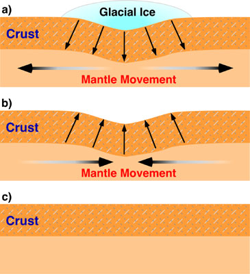
The lithosphere, the uppermost resistent layer of the Earth, rests on the fluid mantle underneath and moves up (or down) in response to weight removed from its surface (or placed on it), such as ice capes, large lakes, mountain ranges, volcanos...
Isostatic sinking (subsidence) and
rebound (uplift) occurring when an
ice sheet forms by climate cooling
and when it is removed by climate warming.
The downwarping (isostatic subsidence)
produced by the ice accumulation in a) is
fully recovered in this process (b and c).
My first steps into geoscience dealt with this concept called isostasy, which looked somewhat simple to a recent graduate in Physics as I was back then, since it simply applies the Archimedes Principle to the Earth's lithosphere.But this idea was just emerging in the late 19th century. And still, G.K. Gilbert was there to get it and to apply it to one of its most conspicuous scenarios: Lake Bonneville. Lake Bonneville was an enormous closed lake (meaning it had no outlet) encompassing the western half of Utah during the Pleistocene. The Great Salt Lake is a small remnant. It would be among the few largest, deepest, and highest lakes today. When its level raised to 1500 m above sea level at the end of the last glaciation, 15,000 years ago, its waters found an exit through the Red Rock pass and the lake was suddenly drained. It produced one of the largest floods ever recorded: the Bonneville Flood (see this previous post). But there was another consequence to the flood: When the lake water was released, the lithosphere under the lake moved upwards to readjust its isostatic equilibrium with the viscous mantle that underlies the Earth's crust. Now, do you believe this story?
I uploaded to Youtube a simple but interesting numerical model. It computes a constant tectonic uplift with the competing river erosion along a cross section, allowing enough time to reach two successive topographic steady states (one during uplift, another one after uplift):
Steady state topography development, and other parameters of the model.
Uplift occurs between x=-50 and x=+50 km. The dashed line indicates
the topographic profile that would develop in absence of erosion.
Equilibrium topography is reached at ~4 and at ~8 Myr.
This is calculated assuming constant uplift rate at the center (x=-50 to +50 km) and a 1D stream power law erosion model. Uplift rate is 1 mm/yr and stops at t=5 Myr. River erosion is proportional to slope and water discharge. Precipitation rate is constant over the entire profile. Calculations are performed under Linux with the program tAo (Garcia-Castellanos, 2007, EPSL). +info and software download here: https://sites.google.com/site/daniggcc/software/tao
As you can see, topographic growth goes on until a first steady state (with a maximum topography of ~3000 m) is reached before 5 Myr. If you look at the numbers, you'll see an equilibrium between erosion rates and uplift rates at that time. At 5 Myr uplift stops and then erosion leads to the new equilibrium: a flat topography (at 8 Myr).
Now, the question is: does steady-state topography exist in nature? And if it does, can we recognize it? In real Earth, neither climate nor tectonics are constant through time. The questions are probably too big for this small blog, but you can find some hints in this article by Willett and Brandon (2001).
Nevertheless, the notion of steady-state topography is useful to understand some basic principles of orogenesis, as Whipple (2009) showed in a very simple and elegant way. Consider these two end-member types of orogen:
Evolution of for parameters (orogen width, erosion, topography, and rock uplift) for two simple models of orogenic growth. Left: fixed width orogen; Right: Self-similar growth. At t=0, the erosion coefficient is set to a double value (red) and to half of the reference value (green). Erosion is assumed proportional to elevation. The parameters are shown normalized. Redrawn from Whipple (2009).
Assume both orogens grow in response to the convergence of two tectonic plates, producing a constant tectonic flow Fa, and that they are eroded at a rate proportional to elevation. The red lines in the figures above correspond to a change to double erosion efficiency. With such a simple representation, it becomes clear that if erosion mechanisms become more efficient, both orogen types initially undergo an increase in erosion rate, but this will gradually decrease back to the initial erosion value (the one compensating the imposed tectonic flow, as in the animation above). The way the orogen returns to the original low erosion rate is by decreasing its elevation R.
One interesting thing is that, whereas for a fixed width, rock uplift rates return to normal after some time, the self-similar growth predicts a permanent increase in uplift rates.
And the other interesting conclusion is that the time response is controlled mainly by the erosion efficiency itself (within the approaches of the model, of course).
Simple models are generally more inspiring than the most complex ones.
References:
Whipple, K. (2009). The influence of climate on the tectonic evolution of mountain belts Nature Geoscience, 2 (2), 97-104 DOI: 10.1038/ngeo413
Willett, S., and Brandon, M. (2001). On steady states in mountain belts Geology, 30, 175-178
Do we need ever-increasing complexity in our models?
Los ordenadores tienen cada vez más capacidad, duplicándola cada ~2 años según la Ley de Moore. Y con ellos aumenta nuestra capacidad para complicar aún más los modelos computacionales con los que aspiramos a entender los cambios en la Tierra. Pero ¿Necesitamos modelos numéricos más complejos? Un modelo con multitud de procesos interconectados, con decenas de parámetros mal acotados, ¿no es tan difícil de interpretar como la propia realidad? ¿Una simulación en la que ya no se sabe qué parámetros son relevantes ni qué significado físico tienen, no pasa a ser más bien una disimulación? Aquí va una interesante discusión al respecto:
Environmental dynamics: Simplicity versus complexity
Nature 469, 7328 (2011). doi:10.1038/469038a
Authors: Chris Paola & Mike Leeder
Many scientists now use the power of computer models to advance their subjects. But there is a choice: to simplify complex systems or to include more detail. Modelling the intricate processes of sedimentary geology is a case in point.