Showing posts with label history of geoscience. Show all posts

2015-11-16

How do we know that the Earth has a core?


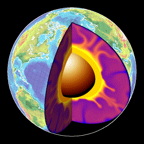
1. A typical depiction of the core
of the Earth.

Many of us have wondered, at some point of our lives, why the cartoons depicting the Earth as a watermelon with a missing portion always show this ball in the center named the 'core'. How do we know that a distinct 'body' is actually down there, 2900 km below the surface?

Let's see: we know the total mass of the Earth through its gravitational interaction with the solar system. In 1797, Cavendish [ref.1] measured the Gravitational constant G and the density of the Earth is ever since known to be about 5.51 times the density of water: nearly twice the average rock density we find at the surface.

In 1898, Wiechert suggested [ref.2] that this high Earth’s density could be explained by a core in the center made of nickel and iron (like many meteorites known at the time) surrounded by a shell, or mantle, of the lighter silicon-dominated rocks that we see in the surface.

2. Inge Lehmann was one of the key
discoverers of the inner core of the Earth.
But only in 1906, Richard D. Oldham found that the increasing speed of seismic waves with depth within the Earth holds only down to 2890 km below the surface. Deeper than that, the mechanical (acoustic) waves propagate much slower (fig. 6), suggesting a different rock nature. Because this distinct material did not transmit shear seismic waves, it became clear that this core is liquid.

But in 1936, Inge Lehmann (picture on the right) found that the center of the core is indeed nearly-solid, since she inferred weak shear waves travelling through it [ref. 4] using highly-sensitive seismometers in New Zealand. This has become known as the inner core.


3. Images of the tsunami following last week's earthquake in Chile.

Today, detecting the core down there has become a doable task for anyone. Last week's earthquake in Chile, for example, provides a great opportunity for you to check if Oldham did everything right. You only need to get seismograms from seismic stations around the world (many of these stations have their data available online, real time), and sort the signals according to the distance from the station to the EQ's epicenter, using the same time of reference, like in this image:
4. Left: Each horizontal line is a seismogram of the Chile earthquake recorded at different locations of the planet (check USGS: 2015-10-16; Mw=8.3). Each seismogram is plotted according to the distance of the measuring station to the earthquake (vertical axis). The red circle shows the signal gap due to the outer core.
Right: Same image, with the identification of the arrivals of the different seismic waves. 'P' waves are the compressional waves, they are first to arrive all around the planet's surface.
The horizontal axis shows elapsed time, measured since the EQ occurred.
The vertical axis shows the distance from the measuring station to the EQ.
The red circle shows the region (around 110 degrees from the source) where the first seismic waves are not recorded. 

5. Seismic shadow produced by an imaginary
earthquake occurring at the north pole. The
outer core, due to its slower seismic velocity,
refracts the mechanical waves of the earthquake,
shadowing a vast region of the planet, as seen
in figure 4.
6. The velocity of seismic waves
changes with depth within the Earth.


In summary: the absence of wave reception in regions around 14,000 km (between 103 and 143 degrees) apart from the hypocenter demonstrates that there is a liquid core where seismic waves travel slow.
Isn't it amazing that nobody realized this before the 20th century?

Finally, remember that the outer core is where the magnetic field of the Earth is generated, by the thermal convection of conductive molten iron around a nearly-solid iron inner core. In fact the changes in the convection patterns in the outer core seem responsible for the rapid historical changes observed in the magnetic field. There is more about the magnetic field in this earlier post.

7. Convection in the iron-dominated outer core around
a nearly solid core is widely accepted as the cause for the 
Earth's magnetic field, and known as the geodynamo
(Glatzmaier & Roberts).
Update 2015-11: a new study suggests that the core (and thus the magnetic field) was formed by the gradual cooling of the Earth only 1 to 1.5 billion years ago.

Update 2015-12: Geophysicists call it the new core paradox: They can't quite explain how the ancient Earth could have sustained a magnetic field billions of years ago, as it was cooling from its fiery birth. Now, two scientists have proposed two different explanations. http://ow.ly/W3eQX

References (thank you nuclearplanet):
1. Cavendish, H., Experiments to determine the density of Earth. Philosophical Transactions of the Royal Society of London, 1798, 88, 469-479.
2. Wiechert, E., Über die Massenverteilung im Inneren der Erde. Nachr. K. Ges. Wiss. Goettingen, Math-Kl., 1897, 221-243.
3. Oldham, R. D., The constitution of the interior of the Earth as revealed by earthquakes. Q. T. Geol. Soc. Lond., 1906. 62, 459-486.
4. Lehmann, I., P'. Publ. Int. Geod. Geophys. Union, Assoc. Seismol., Ser. A, Trav. Sci., 1936, 14, 87-115.

2015-11-03

Conferencias de divulgación geocientífica (50 aniversario del ICTJA)

Con motivo del 50 aniversario de nuestro instituto, cuatro investigadores del ICTJA participamos en el ciclo de conferencias divulgativas en Barcelona: "Las Ciencias de la Tierra en nuestra vida cotidiana", dentro del Cicle Dilluns de Ciència del CSIC-Catalunya.

Lugar: (mapa)
Sala d’Actes de la Residència d’Investigadors,
CSIC-Catalunya,
Barcelona

La conferencias de divulgación son los siguientes lunes:

2 Novembre, 18:30 h,
Charles Darwin, Lord Kelvin, els radioisòtops i el concepte de Temps
Dr. Santiago Giralt

9 Noviembre, 18:30 h
Tambora, 200 años de la erupción que cambió el Mundo
Dra. Adelina Geyer

16 Noviembre, 18:30 h
Megainundaciones, placas tectónicas y la formación del relieve terrestre
Dr. Daniel García-Castellanos

23 Novembre, 18:30 h
Interacció radiació-matèria per a estudiar-ho gairebé tot: nanomaterials, minerals exòtics, obres d’art, cadàvers,...
Dr. Jordi Ibáñez

2014-06-05

Dynamic topography vs. isostasy: The importance of definitions

Fig. 1. Airy isostatic model: every column of rock above the
compensation level should have the same weight.
High topography is compensated by a mass deficit at
the base of the crust (crustal root) 
The term 'Dynamic Topography' is one of the top trending topics in Solid Earth science. It has now prevailed for more than 2 decades, but still the concept involves significant confusion. Dynamic Topography refers to a part of the elevation of the Earth surface that cannot be accounted by the classical crustal isostatic models (Pratt or Airy). But is the term referring to all mantle-sourced loads? Or only to those forces created by the dynamic flow of the mantle? Let's see first where the current confusion exactly comes from.

The term was actually coined by oceanographers to refer to the deviations of the surface of the ocean relative to the Geoid (eg., Bruce, 1968; Wyrtki, 1975). In principle, the geoid should perfectly fit the surface of the ocean, since it is an equipotential surface of the gravity field, but the flow of water adds a secondary shift of the surface, normally less than a meter. This deviation from the surface predicted for a 'static' ocean (ie., the geoid) can be detected in satellite altimetry data because the signal noise introduced by tides, waves, and wind can be removed by time-filtering. The remaining deviation from the geoid is referred to by oceanographers as 'dynamic topography' and is known to be related to the water currents in the ocean.
Fig. 2. Mean ocean dynamic topography from http://grace.jpl.nasa.gov, updated from Tapley et al., 2003).
 It measures the long-term-averaged strength of ocean currents, the 'steady-state'
circulation. 
In the 80s the term was adopted by solid-earth scientists (Hager et al., 1985, Nature). The authors did not follow the original oceanographic meaning, but instead they included 'static' forces originated within the lithosphere (such as the weight of sinking plates, or slab pull) as well as forces caused by flow in the mantle.

Mantle convection model: Mantle temperature (color shading) and flow (arrows). Lines indicate the calculated dynamic topography (blue line) and the horizontal component of plate motion (red, positive means eastward). From Liu et al., 2008, Science
This made sense at the time because there was a big questionmark (still poorly answered today) about the origin of hidden loads, the enigmatic forces needed to explain the depth of sediment accumulations next to mountain belts (see Allen's book Foreland basins, or this article pdf). Sedimentary basins next to orogens in compressional plate boundaries are formed by the isostatic sinking (subsidence) of the lithosphere due to the weight of the growing orogen. These settings became very attractive in solid-earth science not only for prospection purposes, but also because they provide an opportunity to understand how tectonic processes interact with the erosion and transport of sediment in the surface, since the sedimentary layers in such foreland basins record the tectonic evolution of the mountain belt. After many of these foreland basins were modeled, it became clear that the isostatic load of the orogen was generally insufficient to explain the amount of subsidence of the basin. But linking all the hidden load to dynamic effects is misleading, because of the presence of static forces such as the weight of a sinking plate attached to the surface (a lithospheric slab), well known since plate tectonics became mainstream. Another key to understanding the confusion is that before the widespread development of seismic tomography, everything occurring below crustal levels was far more conjectural than today. As a result, part of the Solid-Earth community used the term dynamic topography to refer to all deep-seated forces (originated below the crust) that had an effect on topography, including for instance changes in the thickness of the lithospheric mantle, or a lithospheric slab.

Fig. 3. Two static forces in balance
(weight of the books and the
counteracting human force)
Dynamic forces are added to the
static force to recover the balance
and avoid the books  from falling.
In physics, static vs. dynamic forces refer to whether the forces are in equilibrium (perfectly compensated) or not, and dynamic physical problems refer to motions involving acceleration. This is an additional source of confusion, since both the ocean flow and the Earth's mantle flow can be under steady-state flow and still inflict a constant deflection of the topographic surface, that we yet call 'dynamic'.

But sticking to the original oceanographic definition (as for example in Braun 2010), the dynamic topography of the solid-earth should restrict to the change in elevation produced by dynamic forces related to mantle viscous flow (and flow can only occur beneath the boundary layer of the mantle, underneath the lithosphere). This definition seems robust because the lithosphere is defined based on its strength relative to the underlying asthenosphere, and hence flow-related stresses are expected to be negligible above the lithosphere-asthenosphere boundary (LAB). The fact that the flow is generated by density contrasts does not mean that the forces can be mistaken for static ones, because those density anomalies are out of the rigid body being deformed (the lithosphere).

We therefore can split the observed topography OT into:
OT = CIT + LMIT + MFDT
where CIT is the crustal isostatic topography; LMIT is the Lithospheric-mantle isostatic topography (including slabs attached to the Earth's crust, or the thinning of the lithosphere); and MFDT is the sublithospheric mantle-flow dynamic topography. Note that OT-CIT (easy to calculate using global databases of crustal thickness) is often called residual topography (RT).

Following this notation, the confusion can be described as emanating from some authors referring to LMIT+MFDT (which equals RT) as the dynamic topography, instead of MFDT alone. While this RT ranges in the order of +-1 km, there seems to be no consensus yet as to how large can MFDT be, with values ranging between that same value and a few hundred meters.

Fig. 4. Global free-air gravity anomaly from GRACE. The low values (+-40 mGal) in comparison with the +- 300 mGal that are often attained in smaller regional scales shows that the crust is in overall isostatic equilibrium: the mass excess of topography at high-elevation areas is compensated by a mass deficit at the base of the crust. For this reason there is little correlation between anomaly and continents. The Hawaiian, Yellowstone, Iceland hotspots are represented by highs. Subduction zones show an asymmetrical pair of low & high anomaly. The Hudson Bay undergoes a glacial rebound in response to the deglaciation (+ info here).

Support for the smaller MFDT values comes from reasonings like this: Consider a Stokes sphere sinking or rising in a viscous fluid by virtue of its density contrast with the surrounding fluid (the viscous mantle for us). The vertical velocity of this sphere can be analytically solved and the expression obtained for the dynamic topography it produces depends on its radius a, its density contrast relative to the fluid, the depth of the sphere, and the distance R from the measuring point in the surface to the center of the sphere.
MFDT = ∆h[m] = 2*∆density * a^3 * D * (3D^2+3a^2-5*D^2*a^2/R^2) / (3*fluid_density*R^5) 
Stokes' sphere sinking in a viscous fluid. The gravity anomaly and dynamic topography it generates are linearly proportional to each other.
Because the free-air gravity anomaly produced by the same sphere (∆g) follows a similar equation, the relation between gravity and MFDT conveniently depends only on the of fluid density, to a first approach:
∆g[mGal] = 2πG * density[kg m-3] * MFDT[m]

This means that the +-40 mGal anomalies shown in the global map above should correspond to a dynamic topography smaller that 300-400 m (see P. Molnar's talk linked below).

Clearly, if we knew well the two isostatic contributions CIT+LMIT, then we would be able to attribute the rest to the flow in the mantle and learn about what happens at those depths. As Jean Braun puts it: "Mantle dynamics remain poorly constrained, but by linking mantle flow to surface topography (...) we can use the geological record to constrain the dynamics and viscosity of the mantle and the density structure that controls its flow".
The problem is that there are too many unknowns in the equation: computer models of 3D mantle flow that estimate dynamic topography rely on seismic tomographic imaging of the mantle that provide the distribution of seismic velocity anomaly but how to translate this wave velocity into lateral inhomogeneities in density and viscosity is poorly known. So, fitting the computer models to the weak available observations of dynamic topography and plate tectonic reconstructions will provide only hints on a vague combination of the velocity-viscosity and the velocity-density relationships. So, this will remain as an Earthling Challenge (a Reto Terrícola) for quite some time.

For more information, I recommend Peter Molnar's talk on youtube, Philip Allen's blog post, or Braun's paper listed below. PS: Check also this recent talk by Jean Braun on the interaction between erosion and dynamic topography.


References
  • Allen, 2010, Surface impact of mantle processes, Nature Geoscience.
  • Braun, Jean. "The many surface expressions of mantle dynamics." Nature Geoscience 3.12 (2010): 825-833.
  • Bruce, J. G. "Comparison of near surface dynamic topography during the two monsoons in the western Indian Ocean." Deep Sea Research and Oceanographic Abstracts. Vol. 15. No. 6. Elsevier, 1968.
  • Faccenna, C., Becker, T. W., Auer, L., Billi, A., Boschi, L., Brun, J.-P., Capitanio, F. A., Funiciello, F., Horvath, F., Jolivet, L., Piromallo, C., Royden, L., Rossetti, F., and Serpelloni, E.: Mantle dynamics in the Mediterranean. In press at Rev. Geophys., 2014. PDF
  • Hager, Bradford H., et al. "Lower mantle heterogeneity, dynamic topography and the geoid." Nature 313.6003 (1985): 541-545.
  • Tapley B.D., D.P. Chambers, S. Bettadpur and J.C. Ries, 2003: Large scale ocean circulation from the GRACE GGM01 Geoid. Geophys. Res. Letters 30 (22):doi:10.1029/2003GL018622
  • Wyrtki, Klaus. "Fluctuations of the dynamic topography in the Pacific Ocean."Journal of Physical Oceanography 5.3 (1975): 450-459.

2014-03-26

49 Open Challenges in Earth Science - The Known Unknowns

Mapping Ignorance
ResearchBlogging.org
What keeps Earth scientists busy? These 49 open scientific questions aim at providing an updated, fully-referenced account of the main current scientific questions, disputes, and challenges in Geoscience.


[updated version in this link]


The Early Earth and the Solar System

Advances such as those occurred in the geochemistry of meteorites lead to new exciting hypotheses about the early stages of our planet, but as usual, answers are outnumbered by the new knowledge gaps: 
  1. How did the Earth and other planets form? Were planets formed in situ? Or are orbital changes relatively frequent? What determined the different deep layering of the solar planets? [McKinnon, 2012, Science on Mercury] 
  2. Was there ever a collision of the Earth with another planet Theia, giving birth to our satellite? [Canup, 2013, Science] There is compelling evidence, such as measures of a shorter duration of the Earth's rotation and lunar month in the past, pointing to a Moon much closer to Earth during the early stages of the Solar System. [Williams, CSPG Spec. Pubs., 1991]
  3. What is the long-term heat balance of Earth? How did its internal temperature decay since it formed by accretion of chondrites? How abundant are radiogenic elements in the interior? Did a "faint young sun" ever warm a "snowball Earth"? [WiredMarty et al., 2013, Science]
  4. What made plate tectonics a dominant process only on Earth? [outreach paper] How did the planet cool down before plate tectonics?[Moore & Webb, 2013, Nature] Was the Earth's crust formed during the early stages of its evolution or is it the result of a gradual distillation of the mantle that continues today along with crustal recycling? Is the crust still growing or does its recycling compensate for crust formation at mid-ocean ridges and other volcanic areas?
  5. How inherent to planetary evolution is the development of life conditions? [Zimmer, 2005, ScienceElkins-Tanton, 2013, Nature] Earth-like planets are now known to be abundant in our galaxy (two out of three stars may have one [e.g., Cassan et al., 2012, Nature]), but how many of them develop widespread durable water chemistry? How much of our water supplied by comets or asteroids? When and how did it reach the Earth? [outreach article]

Earth’s Interior

Our rock-sampling reach is limited to the upper 12 km of the Earth's crust, but the keys to extend our knowledge often lay far deeper than that. Indirect measurements such as seismic wave tomography, together with geodynamic and petrological modeling, become crucial: 
  1. What are the chemical composition and mechanical properties of rocks in the Earth’s mantle at the extreme pressure and temperature they undergo? As planets age and cool off, their internal and surface processes coevolve, chemically and mechanically, shaping also the atmospheric composition. Therefore this question has direct implications for our understanding of the environmental evolution of the Earth. [Kerr, 2005, Science]
  2. What are the dynamic processes in the Earth interior that accommodate and fuel plate tectonics? As seismometers spread more evenly over the planet's surface, the seismic imaging of the interior will rapidly improve, providing a detailed distribution of seismic wave velocity. Simultaneously, lab-based mineral physics must better constrain what these mechanical wave velocities tell us about the hot, deep rocks of uncertain composition in the mantle. Only then will computer models be able to test the proposed geodynamic models by trying to fit quantitatively those data and other geophysical observations such as gravity variations. [ref.3]
  3. Sedimentary and volcanic rocks have recorded changes of the magnetic field throughout the evolution of the Earth. What causes the sudden reversals of the paleomagnetic field? How does the geomagnetic field link to the iron convection properties at the deep Earth? Or inversely, what can we learn about the mechanical behavior of the materials at those depths from the geomagnetic field? [more context in Nature] Are the magnetic reversals too fast to be related to core dynamics? [example.1] [ex.2] [ex.3] Could their frequency be related to the distribution of tectonic plates? [GRL article]. What causes superchrons (periods longer than 10 Myr without magnetic reversals)? Something internal to the core, or induced externally by the mantle/subducting slabs? Was the geomagnetic field always dipolar, or was it more asymmetric in the past? [introduction]
  4. Are intraplate hotspots really made by deep sources of uprising materials (mantle plumes) coming from the deepest Earth's mantle? Or can they be explained by shallower convection? [e.g., Morgan, 1971; see also this recent Geology paper on Yellowstone].
  5. What is the history of and what controls the excursions of the rotation pole relative to the surface geography, known as true polar wander? [ex]
  6. What are the properties of deep rocks? How can we translate the heterogeneity in density, seismic wave velocity, or electromagnetic resistivity presently observed in the mantle and the lithosphere into variations of the mineralogical composition? And how do these measures relate to the dynamics of the Earth and to key mechanical properties such as the viscosity? [Faccenna & Becker, 210, Nature]. 
  7. What are the causes for Large Igneous Provinces and massive flood basalts such as the Columbia River Basalts?

Tectonic-plate motion and deformation 

The successful adoption of the plate tectonics paradigm has lead to a myriad of new questions about its limits and about the lessons for risk mitigation.
Velocity of the earth's surface at the Indian-Asian collision,
from GPS data. Blue star indicates the 2008 China earthquake.
Source: CALTECH
  1. What is the relative importance of the forces driving plate tectonics: slab pull, slab suction, mantle drag, and ridge push? [e.g., Conrad & Lithgow-Bertelloni, 2004; Negredo et al., GRL, 2004, vs. van Benthem & Govers, JGR, 2010]. What is the force balance and the geochemical cycle in subduction zones? [Emry et al., 2014, JGR] How much water (and how deep) penetrates into the mantle? [Ranero et al., 2003, Nature] How much subcontinental erosion takes place under subduction areas? [Ranero et al., 2000, Nature]
  2. What happens after the collision of two continents? Does continental collision diminish the rate of plate subduction, as suggested by the slab-pull paradigm? [Alvarez, EPSL, 2010How frequent are the processes of mantle delamination and slab break-off? What determines their occurrence? [Magni et al., GRL, 2013; Durezt & Gerya, Tectonoph., 2013]
  3. Why are orogens curved when seen from space? [Weil & Sussman, 2004, GSASP 383]
  4. How does the long-term deformation derived from paleomagnetism and structural geology link quantitatively to the present-day motions derived from GPS and from neotectonic patterns of crustal deformation? [Calais et al., EPSL, 2003] How do these last two relate to each other? [ref] Can we learn from regional structure of the crust/lithosphere from that link (or viceversa)? 
  5. Are plate interiors moving in steady-state linear motion? How rigid are these and why/when did they deform? [Davis et al., (2005) doi:10.1038/nature04781, and Wernicke & Davis, (2010) doi:10.1785/gssrl.81.5.694]
  6. How is the relative motion between continents accommodated in diffuse plate boundaries? (eg., the Iberian/African plate boundary). What determines the (a)seismicity of a plate contact? 
  7. How/when does deformation propagate from the plate boundaries into plate interiors? [e.g., Cloetingh et al., 2005, QSR] 
  8. What is the rheological stratification of the lithosphere: like a jelly sandwich? Or rather like a creme brulée? [Burov & Watts, 2006]. Is the lower crust ductile? Is strength concentrated at the uppermost mantle? Or just the other way around? [e.g., McKenzie et al., 2000, JGR; Jackson, 2002, GSA TodayHandy & Brun, 2004; and a nice recent post]
  9. Add caption
      Does the climate-controlled erosion and surface transport of sediment modify the patterns of tectonic deformation? Does vigorous erosion cause localized deformation in the core of mountain belts and prevent the propagation of tectonic shortening into the undeformed forelands? Does the deposition of sediment on the flank of mountains stop the frontal advance of the orogen? Is there any field evidence for these effects predicted from computer models? [Philip Allen's blog] [Willett, 1999, JGRWhipple, 2009Garcia-Castellanos, EPSL, 2007]
    1. Can earthquakes be predicted? [Heki, 2011, GRLFreed, 2012, Nat.Geosc.]. How far away can they be mechanically triggered? [Tibi et al., 2003, Nature]. Little is known about how faults form and when do they reactivate [ex.6], and even worse, there seems to be no clear pathway as to solve this problem in the near future. Unexpected breakthroughs needed. 
    2. How can the prediction of volcanic eruptions be improved? What determines the rates of magma accumulation in the chamber and what mechanisms make magmas eruptible? [ex.7][ex.7b]
    3. In many regions, the elevation of the continents does not match the predictions from the classical principle of isostasy for the Earth's outer rigid layer (the lithosphere). This deviation is known as dynamic topography, by opposition to isostatic topography. But what are the mechanisms responsible? Can we learn about the mantle dynamics by estimating dynamic topography? [ref.1Can the hidden loads needed to explain the accumulation of sediment next to orogens (foreland basins) be linked to these dynamic forces? [Busby & Azor, 2012, Wiley]
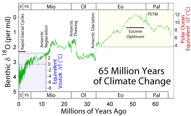
    4. How do land-forming processes react to climate change at a variety of scales, ranging from the Milankovitch cycles to the late Cenozoic cooling of the Earth? Is there a feedback from erosion into climate at these time scales, through the Carbon cycle and the weathering of silicates, for example? What is the role of the surface uplift and erosion of Tibet on the drawdown of atmospheric CO2 over the Cenozoic? [Garzione, 2008, Geology]

    Earth's landscape history and present environment

    The shape of the planet's solid surface, its topography, is the key feature that connects many of the disciplines within Earth science, probably because it is the feature that most affects our daily life. It is today common wisdom that landscape forms from a complex interplay between tectonics and climate, through a list of mechanical, chemical, and biological processes acting at the surface of the Solid Earth. Topographic data is becoming now available at resolutions finer than a few meters, and the sedimentary record is also being archived at unprecedented rates. But:
    Drainage patterns in Yarlung Tsangpo River, China (NASA)

    1. Can we use these data to derive past tectonic and climatic conditions? Will we ever know enough about the erosion and transport processes? Was also the stocasticity of meteorological and tectonic events relevant in the resulting landscape? And how much has life contributed to shape the Earth's surface? 
    2. Can classical geomorphological concepts such as 'peneplanation' or 'retrogressive erosion' be understood quantitatively? Old mountain ranges such as the Appalachian or the Urals seem to retain relief for > 10^8 years, while fluvial valleys under the Antarctica are preserved under moving ice of kilometric thickness since the Neogene. What controls the time-scale of topographic decay? [Egholm, 2013, Nature]
    3. What are the erosion and transport laws governing the evolution of the Earth’s Surface?[Willenbring et al., Geology, 2013] Rivers transport sediment particles that are at the same time the tools for erosion but also the shield protecting the bedrock. How important is this double role of sediment for the evolution of landscapes? [Sklar & Dietrich, Geology, 2001 (tools and cover effect); Cowie et al., Geology, 2008 (a field example)].
    4. Can we predict sediment production and transport for hazard and scientific purposes? [NAS SP report, 2010Geology, 2013] 
    5. Smaller-scale patterns at the limit
      between river channels and hillslopes.
      Credit: Perron Group, MIT
    6. What do the preserved 4D patterns of sediment flow tell us from the past of the Earth? Is it possible to quantitatively link past climatic and tectonic records to the present landforms? Is it possible to separate the signals of both processes? [e.g., Armitage et al., 2011, Nature Geosc]. 
    7. Can we differentiate changes in the tectonic and climate regimes as recorded in sediment stratigraphy? Some think both signals are indeed distinguishable [Armitage et al., 2011, Nat.Geo.]. Others (Jerolmack & Paola, 2010, GRL], argue that the dynamics intrinsic to the sediment transport system can be 'noisy' enough to drown out any signal of an external forcing. 
    8. Does surface erosion draw hot rock towards the Earth’s surface? Do tectonic folds grow preferentially where rivers cut down through them, causing them to look like up-turned boats with a deep transverse incision? [Simpson, 2004, Geology]
    9. How resilient is the ocean to chemical perturbations? What caused the huge salt deposition in the Mediterranean known as the Messinian Salinity Crisis? Was the Mediterranean truly desiccated? What were the effects on climate and biology, and what can we learn from extreme salt giants like this? [e.g., Hsu, 1983Clauzon et al., Geology, 1996; Krijgsman et al, 1999, NatureGarcia-Castellanos & Villaseñor, Nature, 2011]. Were the normal marine conditions truly reestablished by the largest flood documented on Earth, 5.3 million years ago? [Garcia-Castellanos et al., 2009, Nature]
      Artistic view of the refilll of the
      Mediterranean after the Messinian salinity
      crisis. Authors: Pibernat & Garcia-Castellanos.
      Downloadable here.
    10. How do the patterns of river networks form? [eg. Devauchelle et al., 2012, PNAS; Perron et al., 2012, Nature]. And what information about the past do these patterns contain? Can we quantitatively reconstruct past ecology or climate from old river patterns? [e.g., Hartley et al., 2010, J. Sedim. Res.]
    11. Do we need a new geological epoch called Anthropocene? When do the Homo Sapiens start to have a significant impact on the Earth System? 8000 BP?[Ruddiman, 2003, Climatic Change]; 2000 BP? [Scalenghe, 2011, The Holocene]; 1850 AD? [Crutzen & Steffen, 2003]

    Climate, Life, and Earth

    Source: R.E..Rhode, Wikipedia
    The geological record shows that climate is relatively stable over tectonic time-scales whereas it undergoes abrupt changes in periods ranging from decades to hundreds of thousand years. Past periods when the planet underwent extreme climate conditions may help to understand the mechanisms behind that behavior and its significance for the evolution of the Solid Earth.

    1. What caused the largest carbon isotope changes in Earth? [Grotzinger et al., 2011, Nat. Geosc.] How does Earth’s climate system respond to elevated levels of atmospheric CO2? 
    2. Was there ever a snow-ball Earth during the earliest stages of Life on Earth? 
    3. Were there also rivers and lakes on Mars? [Hans, 2012] Were there large outburst floods similar to those on Earth
    4. What were the causes and what shaped the recovery from mass extinctions as those at the K-T boundary, the Permian-Triassic or the Late Triassic? Massive volcanism? Meteorites? Microbes? [recent papers: ex.8ex.9ex.10, Rothman et al., 2014, PNAS]
    5. What triggered the extreme climatic variability during the Quaternary and the roughly coeval acceleration in continental erosion and sediment delivery to the margins? [Peizhen, Molnar et al., 2001, Nature; Herman et al., 2013, NatureWas this related to the tectonic closure of the Central American Seaway? How do these climate events translate quantitatively into sea level changes?
    6. How do climate changes translate quantitatively into sea level changes? How do ice sheets and sea level respond to a warming climate? What controls regional patterns of precipitation, such as those associated with monsoons or El Niño?
    7. What caused the Quaternary extinction(s)? Human expansion? Climate Change? How sensitive are ecosystems and biodiversity to environmental change? Was the large fauna extinction ~13,000 yr ago a result of the Younger Dryas climatic event? Was this caused by an extraterrestrial impact? [ex.11ex.12] Or may it be linked to the outburst of Lake Agassiz
    8. How relevant are subsurface microorganisms to earth dynamics by controlling soil formation and the methane cycle? What are the origin, composition, and global significance of deep subseafloor communities? What are the limits of life in the subseafloor realm?  
    9. The atmosphere is shaped by the presence of life, a powerful chemical force. The Earth’s evolution has seems to affect the evolution of life [see the Cambrian explosion of animal life, for instance; plus this recent paper on that]. To what extent? And how much control has life on climate? [another recent one]. Is it possible to quantify these links to make reliable predictions that allow filling the data gaps or assessing the chances for extraterrestrial life?
    10. How much of the present climate change is anthropogenic? How will growing emissions from a growing global population with a growing consumption impact on climate? 

    Broader open questions


    1. Many of the questions above are related to the extreme diversity of spatial scales of Earth processes. Direct observation (by sampling or remotely) is mostly limited to a thin layer around the solid surface of the Earth, and physical experimentation is limited to the pressures of the uppermost layers of the planet. Many processes including plate tectonics are known to be driven by the nature of the materials that make up the planet interiors, down to the smallest atomic scales, as thought for instance for the trigger of earthquakes. Answers may arrive via new devices and analytical tools working at the high pressures and temperatures of Earth’s interior.
    2. Time scales also pose a problem to know the mechanical and chemical properties of Earth's materials. Partly because we deal with time scales in very different orders of magnitude while we are limited to make observations from the present. But also because scaling the rates of lab experiments (e.g., mineral physics) or analogue models (e.g., sandbox experiments) with the corresponding geological scenarios is not always convincing. 
    3. Implementing Episodicity in Gradualism: For historical reasons, geology has generally underestimated the role of episodicity in nature. However, there is a growing view that exceptional events and stochasticity have a relevant role in many of Earth's subsystems. An example for this is the preeminence of flooding events (larger than average) in erosion and surface sediment transport and during the evolution of landscape, and the importance of upscaling flood stochasticity into sediment transport models [eg., Lague, 2010, JGR]. Climate variability at all time-scales has been already mentioned above. Even plate tectonics may have been episodic (during the Archean at least, [ref]).  4D hyperscale data sets in geomorphology are increasingly showing the limits of smooth-process approaches. Future understanding of the Earth will benefit from incorporating the full frequency spectrum (the episodicity) in modeling natural phenomena, rather than systematically approaching these as gradual processes. 
    4. Computer models tell whether the complexity of nature can be explained by the interplay between simple processes, but: how can we further model the Earth as a complex system of complex systems? And when can we expect ‘compact’ explanations? 

    General background:
      Note that the specific references given above for each open question are sometimes just examples and may not always be the best representative. Furthermore, the list is surely biased towards Solid Earth Science, my own field. The following general references can give you an alternative perspective on the subject.
      Please send additions/suggestions to d.g.c@csic.es

      Acknowledgements:
      For various inputs/criticisms to this list: Brian Romans, Umberto Lombardo, Jean Braun, Mikael Attal, Alexandra Witze, Michael Klaas, Matt Hall, Chris Rowan.
      PD: I published a shorter version of this post in Mapping Ignorance. -Daniel

      2013-11-27

      How old is Earth Science?

      Many geoscientists think of their field as not much older than Lyell or Hutton; as a science that bloomed sometime during the eighteenth century. Nevertheless, the term geology was first used by Ulisse Aldrovandi in 1603 (Vai and Cavazza, 2003) and introduced as a regular term by Horace de Saussure in 1779. The danish scholar Nicolas Steno (1638-1686) set the bases for stratigraphy: the law of superposition and the principle of original horizontality.

      But the roots of the scientific interest for the history of the Earth are even deeper than that.

      Ortelius' world map, inspiring his own anticipation of
      continental drift
      In 1596 Abraham Ortelius, a flemish geographer serving the Spanish crown, wrote: "America (...) was (...) torn away from Europe and Africa, by earthquakes and flood" "the vestiges of the rupture reveal themselves: if someone brings forward a map of the world and considers carefully the coasts of the three aforementioned parts of the earth, where they face each other". This quotation extraordinarily anticipated by more than three centuries the theory of continental drift, but it remained forgotten and was rediscovered only in 1994.
      Ortelius' idea was in turn a direct result of the vast exploration discoveries that took place in the previous decades. In the words of Alvarez & Leitao (2012, Geology): "The Iberian Voyages of Discovery of the fifteenth and sixteenth centuries marked a major advance in the understanding of the Earth—the greatest advance since antiquity, and comparable in scope and importance with the Geological Revolution, the Darwinian Revolution, and the Plate Tectonic Revolution, and we encourage geologists and other Earth scientists to embrace the Voyages as part of our geological scientific heritage."
      This Edmund Halley’s map of geomagnetic declination (~1700 
      AD) came about two centuries later than similar studies by 
      Portuguese explorers, who used these magnetic anomalies for the 
      long-lived challenge of determining longitude during navigation.

      The practical drive behind those first geoscientific questions? In the 16th century, "the Portuguese began to make systematic surveys of magnetic declination by comparing the direction of a compass needle with the line of shadow of the Sun at local noon". Magnetic declination could in this way be used to estimate the geographical longitude, a fundamental navigation problem at the time which final solution had to wait for the eighteenth century, when accurate chronometers were first developed. In fact, it turns out that the phenomenon was well known since centuries earlier, and by 1492, Columbus first described the agonal line in the Atlantic Ocean, where the compass points exactly to the geographic pole.

      In 1736, a franco-spanish expedition is set to south America to determine the size and shape of the globe, whether it is flattened or elongated at its poles, a long standing scientific question at the time. The expedition included Charles de La Condamine, Jussieu, Pierre Bouguer, Jorge Juan & Antonio de Ulloa. Several books were published out of these expeditions that had great novelty and impact at the time. Juan & Ulloa's (Relacion historica del viage a la America Meridional hecho de orden de S. Mag. para medir algunos grados de meridiano terrestre y venir por ellos en conocimiento de la verdadera figura y magnitud de la tierra, con otras observaciones astronomicas y phisicas), was published 3 years after La Condamine's but showed far more detail, maps and illustrations.
      Juan & Ulloa's cover, 1748


      In summary, the systematic study of the Earth has a history behind as long as in any other scientific field. Quoting again A&L: geoscientists can "trace their intellectual ancestry back to the Copernican Revolution of the 16th and 17th centuries, just as astronomers and physicists do".

      References:
      • Alvarez & Leitao, 2010, Geology, 38, 231–234, doi: 10.1130/G30602.1
      • Romm, James, Nature 367, 407-408, 1994, A new forerunner for continental drift. doi:10.1038/367407a0
      • G. B. Vai et W. Cavazza, ed, Four centuries of the word 'Geology', Ulisse Aldrovandi 1603 in Bologna, Minerva Edizioni, Bologna, 2003

      2013-01-07

      Preguntas abiertas en la geociencia - borrador

      ResearchBlogging.org
      [Esta lista responde a una curiosidad personal sobre las preguntas científicas que mantienen ocupados a quienes investigan sobre la Tierra, principalmente en disciplinas relacionadas con la tierra sólida. Un borrador inicial lo esbocé a partir de estudios anteriores (por ejemplo, el del 125 anniversario de Science. o el informe de la NAS Origen y evolución de la Tierra [pdf] [html], o este otro informe de la NAS sobre procesos de superficie), y finalmente con más ideas que surgieron a través de Twitter, discusiones, y de esta entrada del blog anterior. La selección es por tanto arbitraria y las referencias no siempre son las más adecuadas. Cualquier sugerencia serán tenida en cuenta para la versión final. Si crees que tu campo es muy excitante pero está poco o mal representado, por favor, deja un comentario o contacta a través de Twitter con @danigeos]

      [Updated English version here; La versión inglesa tiene actualizaciones significativas.]

      La Tierra Primitiva y el Sistema Solar 
      1. ¿Cómo se formaron la Tierra y los demás planetas del sistema solar? ¿Se formaron in situ o han cambiado frecuentemente de órbita? ¿Qué causó la distinta estructura de capas de los planetas solares? [Reciente artículo en Science sobre Mercurio]
      2. ¿Colisionó la Tierra primitiva con otro planeta (Theia), dando origen a nuestro satélite? Sólo hay pruebas circunstanciales, tales como medidas de la duración de la rotación Terrestre y del mes lunar en el pasado, que apuntan a una Luna mucho más próxima a la Tierra durante las primeras etapas del Sistema Solar.
      3. ¿Porqué la tectónica de placas domina el paisaje sólo en la Tierra? [artículo de divulgación] ¿Se formó la corteza de la Tierra durante las primeras etapas de su evolución o es el resultado de una destilación gradual del manto que compite en la actualidad con el reciclaje de la corteza en las zonas de subducción? ¿Crece la cantidad de corteza o consigue ese reciclaje compensar su formación en las dorsales centro-oceánicas y otras zonas volcánicas?
      4. ¿Cuál ha sido el balance energético de la Tierra en escalas de tiempo geológicas? ¿Cómo descendió su temperatura interna desde que se formó por la acreción de condritas? ¿Cómo de abundantes son los elementos radiogénicos en su interior? ¿Pudo alguna vez un "sol débil y joven" calentar la "bola de nieve" terrestre?
      5. ¿Cómo de inherente a la evolución planetaria es el desarrollo de condiciones para la vida? [Ref. 1] Sabemos ahora que los planetas similares a la Tierra son abundantes en nuestra galaxia (dos de cada tres estrellas pueden serlo [por ejemplo, Nature, 2012]), pero ¿cuántos de ellos desarrollan una química duradera basada en el agua?


      Interior de la Tierra

      1. Cuando los planetas se enfrían, sus procesos internos y los de la superficie coevolucionan, química y mecánicamente, configurando la composición de la atmósfera. ¿Cuál es la composición química y las propiedades mecánicas de las rocas en el manto de la Tierra a la presión y temperatura extremas que sufren? [ref.2]
      2. ¿Cuáles son los procesos dinámicos y químicos en el interior de la Tierra que mantienen la tectónica de placas? La futura proliferación de sismómetros de una forma más uniforme sobre la superficie del planeta permitirá obtener imágenes sísmicas del interior mucho mejores, proporcionando una distribución detallada de velocidad de las ondas sísmicas. Al mismo tiempo, los laboratorios de física de minerales delimitarán mejor lo que estas velocidades de las ondas mecánicas nos dicen sobre la composición del manto a las altas profundidades y temperaturas en que se encuentran allí las rocas. Sólo entonces los modelos informáticos podrán poner a prueba los modelos geodinámicos propuestos y tratar de encajar cuantitativamente estos datos y otras observaciones geofísicas tales como variaciones de la gravedad. [ref.3]
      3. ¿Cómo encaja el campo geomagnético con las propiedades convectivas del hierro en el interior terrestre? ¿Qué podemos aprender acerca del comportamiento mecánico de los materiales en esas profundidades a partir del campo geomagnético [contexto más? Nature] Los cambios geomagnéticos se registran en las rocas, por lo que proporcionan una vista de la Tierra en el pasado: ¿Son las inversiones magnéticas demasiado rápidas para estar relacionadas con la dinámica del núcleo? [Ejemplo.1] [Ej.2] [Ej.3] Podría su frecuencia estar relacionada con la distribución de las placas tectónicas? [GRL artículo]. ¿Qué causa los supercrones (largos períodos sin inversiones magnéticas)? Algo interno al núcleo, o inducido externamente por el manto o placas en subducción? ¿El campo geomagnético fue siempre dipolar, o fue más asimétrico en el pasado? [introduction]
      4. ¿Los hotspots de intraplaca han sido creados por fuentes procedentes del manto inferior de la Tierra? ¿O pueden ser explicados por una convección más somera? [Por ejemplo, Morgan, 1971 , o este documento reciente sobre la geología de Yellowstone].
      5. ¿Qué nos dice acerca de la dinámica de la Tierra la heterogeneidad de la densidad, composición y velocidad de las ondas sísmicas en el manto y en la litosfera? [ej.3]
      6. ¿Que formó las grandes provincias ígneas y los basaltos masivos de inundación como los basaltos de la cuenca del río Columbia?

      Movimiento de las placas tectónicas y la deformación

      1. ¿Cómo se transforma el movimiento del manto terrestre en motor de la tectónica de placas? [Por ejemplo, Negredo et al., GRL, 2004, frente a van Benthem y Govers, JGR, 2010]. ¿A qué profundidades tiene lugar esa transferencia de momento? ¿La colisión continental frena la subducción de la placa, como sugiere el paradigma del slab-pull[Walter Alvarez, EPSL, 2010]
      2. ¿Encaja la deformación de largo plazo (deducida del paleomagnetismo y de la geología estructural) con los movimientos actuales derivados a partir de GPS y de la deformación neotectónica en la corteza? [Calais et al., EPSL, 2003] ¿Cómo se relacionan estas observaciones y qué podemos aprender sobre la estructura de la litosfera combinándolas? [ref] ¿Cómo y cuándo se propaga la deformación tectónica hacia el interior de las placas? [Por ejemplo, Cloetingh et al., 2005, QSR ]  
      3. ¿El movimiento de las placas está en estado estacionario? ¿Cómo de rígidas son éstas? ¿por qué y cuándo se deforman? [Davis et al, (2005) doi:. 10.1038/nature04781 y Wernicke & Davis, (2010) doi: 10.1785/gssrl.81.5.694]
      4. ¿Cómo se acomoda el movimiento relativo entre continentes a lo largo de los límites difusos de placa? (por ejemplo, el límite entre Iberia y África). ¿Qué determina la (a)sismicidad de un contacto de placas?
      5. Cómo y cuándo se propaga la deformación de los bordes de los continentes hacia el interior de los mismos? [e.g., Cloetingh et al., 2005, QSR] 
      6. Cómo está estratificada la resistencia mecánica de la litosfera: ¿como un jelly sandwich? (con la corteza inferior débil rodeada por corteza superior y manto resistentes) ¿O más bien como una créme brulée? (con una corteza resistente reposando sore el manto dúctil) [Burov & Watts, 2006]. ¿Se concentran los esfuerzos en el manto superior? ¿O justo al contrario? [Por ejemplo, McKenzie et al, 2000;. Jackson, 2002; Handy & Brun, 2004, y un bonito post reciente].
      7. ¿Puede el clima influir en la deformación tectónica? ¿Hay alguna evidencia de campo que confirme la hipótesis de que la erosión y el clima pueden cambiar los patrones de deformación tectónica (como predicen los modelos informáticos)? [Willett, 1999; Whipple, 2009 ; García-Castellanos, EPSL, 2007]
      8. ¿Pueden predecirse los terremotos? [Ej.4 , ej.5]. La evaluación de riesgo sísmico se basa sobretodo en pronósticos basados a su vez en estadísticas de terremotos en el pasado. Poco se sabe acerca de cómo se forman las fallas y cuándo se reactivan [ej.6], y lo que es peor, no parece haber ningún camino claro para resolver este problema en un futuro próximo. Habrá que esperar a algún descubrimiento inesperado.
      9. ¿Pueden predecirse las erupciones volcánicas? ¿Qué determina las tasas de acumulación de magma en las cámaras magmáticas y qué mecanismos desencadenan la erupción? Este es otro campo que parece casi tan necesitado de avances fundamentales como el anterior. [ej.7]
      10. A menudo las predicciones de los modelos de isostasia no se ajustan perfectamente a la elevación observada. A la diferencia entre ambos conceptos se le llama topografía dinámica, pero se sabe muy poco sobre su origen. ¿Podemos aprender sobre la convección en el manto a partir de su estudio?

      La historia de la superficie terrestre y el medio ambiente actual

      Mediterráneo desecado (Autor: Roger Pibernat)
      1. Es comúnmente aceptado que el relieve terrestre es el resultado de una compleja interacción entre la deformación tectónica, el clima, y una serie de procesos mecánicos, químicos y biológicos que actúan sobre la superficie de la tierra sólida. La masiva disponibilidad de  modelos topográficos con resoluciones de unos pocos metros ha servido de base y de desafío para una mejor comprensión de la evolución del relieve. Pero, ¿podemos utilizar la topografía para deducir los movimientos tectónicos del terreno?, ¿y para derivar las condiciones climáticas pasadas? ¿Sabemos lo suficiente acerca de los procesos de erosión? ¿es la estocasticidad de los eventos meteorológicos y tectónicos relevante en el paisaje terrestre? ¿Y cuánto ha contribuido la vida a dar forma a la superficie de la Tierra?
      2. ¿Se pueden predecir o cuantificar conceptos geomorfológicos clásicos como la peniplanación (enrasamiento progresivo del relieve por la erosión)? Algunas cadenas montañosas como los Apalaches o los Urales retienen su relieve durante periodos de 10^8 años, y numerosos valles fluviales se han conservado bajo kilómetros de hielo antártico en movimiento durante millones de años. ¿Qué determina que el relieve persista durante periodos de tiempo tan largos?  
      3. ¿Podemos predecir cuantitativamente la producción y el transporte de sedimentos para evaluar riesgos o para fines científicos? ¿Qué leyes rigen la erosión y el transporte que gobiernan la evolución de la superficie de la Tierra? [NAS SP informe de 2010] ¿Es posible relacionar cuantitativamente los nuevos registros climáticos y tectónicos con el registro sedimentario? ¿Es posible separar las señales de ambos procesos?   [Por ejemplo, Nature Geosc ].  
      4. ¿Hasta qué punto quedan grabadas las perturbaciones del clima y la tectónica en el registro estratigráfico? Jerolmack y Paola [2010, GRL] sostienen que la dinámica del transporte de sedimentos puede ser suficientemente "ruidoso" como para borrar cualquier señal de una fuerza externa.
      5. ¿Como se han formado los gigantes salinos de la geología? ¿Qué causó y cómo evolucionó el enorme depósito de sal en el Mediterráneo durante la Crisis de Salinidad Mesiniense? ¿Llegó adesecarse el Mediterráneo? ¿Cuáles fueron los efectos sobre el clima y la biología, y qué podemos aprender de los eventos extremos como estos? [Por ejemplo, Hsu, 1983; Clauzon et al, Geología, 1996; Krijgsman et al, 1996; García-Castellanos, 2011 ]
      6. ¿Podemos reconstruir cuantitativamente la ecología y el clima pasados en base a los  patrones fluviales? [Por ejemplo, Hartley et al., 2010, J.Sedim.Res.]


      El clima, la Vida y la Tierra Sólida

      El registro geológico muestra que el clima es relativamente estable en las escalas de tiempo de la tectónica de placas mientras que sufre cambios cíclicos ligados a cambios orbitales, en escalas de entre 20.000 y un millón de años. En períodos más cortos, de entre décadas y milenios, estos cambios son también muy significativos, pero peor comprendidos. El estudio del pasado terrestre, de épocas en las que el planeta estuvo sometido a condiciones climáticas extremas, puede ayudar a entender los mecanismos responsables. 

      1. ¿Qué causó el mayor cambio isotópico del carbono en la Tierra? [Nat.Geo revisión]  
      2. ¿Fue la Tierra una enorme "bola de nieve" durante las primeras etapas de la vida?
      3. ¿Hubo también ríos y lagos en Marte? ¿Hubo grandes inundaciones explosivas similares a las de la Tierra?
      4. ¿Cuáles fueron las causas de las extinciones en masa como la del límite KT, el Pérmico-Triásico o el Triásico Tardío? ¿qué controló la recuperación?  [Artículos recientes: ej.8 , ej.9ej.10 ]
      5. ¿Qué desencadenó la extrema variabilidad climática del Cuaternario y la aceleración más o menos coetánea del ritmo de erosión continental y de sedimentación en los márgenes de los continentes? [Peizhen, Molnar et al., 2001] ¿Alguna relación con el cierre tectónico del Estrecho de América Central? ¿Cómo se traducen cuantitativamente estos cambios del clima en cambios del nivel del mar?
      6. ¿Qué causó las grandes extinciones del Cuaternario? ¿La expansión humana? ¿El cambio climático? ¿Fue la extinción de gran fauna hace unos 13.000 años un resultado del evento climático conocido como Younger Dryas? ¿Fue causado por un impacto meteorítico? ej.11 , ej.12 ] ¿O podría estar relacionada con el desagüe repentino del lago Agassiz ?
      7. ¿Qué relevancia tienen los microorganismos del subsuelo en la dinámica de la tierra por su control de la formación del suelo y del ciclo del metano (clima)?
      8. La composición de la atmósfera está ligada a la presencia de vida, una fuerza química de gran alcance [Artículo reciente]. La evolución de la Tierra ha afectado claramente la evolución de la vida (ver la explosión cámbrica de vida animal, por ejemplo; un reciente documento). ¿En qué medida la evolución está determinada por la geología? ¿Es posible cuantificar estos enlaces para hacer predicciones confiables que permitan llenar los vacíos de información o la evaluación de las posibilidades de vida extraterrestre?
      9. ¿Qué parte del cambio climático actual es antropogénico? ¿Cómo van impactar en el clima las crecientes emisiones de una población mundial cada vez mayor? Una buena parte de la respuesta parece estar en el pasado remoto del planeta. 

      Cuestiones abiertas más generales


      1. Muchas de las preguntas anteriores están relacionadas con la enorme variabilidad de escalas espaciales y temporales de los procesos terrestres. La observación directa (mediante muestreo de roca o mediante teledetección remota) se limita a una capa delgada alrededor de la superficie sólida de la Tierra, y la experimentación física se limita a las presiones de las capas más superficiales del planeta. Muchos procesos, incluyendo la tectónica de placas dependen de la naturaleza de los materiales que componen la roca, hasta las más pequeñas escalas atómicas. Las respuestas pueden llegar a través de nuevos dispositivos y herramientas analíticas que trabajan a muy altas presiones y temperaturas como las del interior de la Tierra.
      2. La diversidad de escalas de tiempo involucradas en la evolución terrestre también plantean un problema a conocer las propiedades mecánicas y químicas de los materiales. En parte porque se trata de escalas de tiempo que varían en muchos órdenes de magnitud, mientras que nuestras observaciones están limitadas al presente. Pero también debido a que la comparación de los experimentos de laboratorio (por ejemplo, la física de minerales) o modelos analógicos (por ejemplo, los experimentos en sandbox)  con la geología no siempre es convincente.
      3. Implementación de la episodicidad en el gradualismo: Por razones históricas, la geología en general ha subestimado el papel de la episodicidad en la naturaleza. Sin embargo, los acontecimientos puntuales o excepcionales tienen un peso relevante en muchos subsistemas terrestres. Un ejempo sería el efecto de las grandes inundaciones en la evolución del paisaje. Ya he mencionado la importancia de la variabilidad del clima. También la tectónica de placas pudo haber sido episódica ya durante el Arcaico [ref] y como bien sabemos la deformación tectónica en escalas de tiempo humanas se produce en forma de terremotos, de forma impredecible y episódica. El entendimiento futuro de la Tierra se beneficiará de la incorporación de todo el espectro de frecuencias (la episodicidad) a los modelos de fenómenos naturales, en lugar de aproximarnos sistemáticamente a estos procesos como si se trataran de fenómenos graduales.

      Referencias generales:
      Zwaan, J. (2010). Origin and evolution of earth: Research questions for a changing planet by the committee on grand research questions in the solid-earth sciences, National Research Council. National Academies Press, Washington, D.C., 2008. No. of pages: 137. (paperback). Geological Journal, 45 (2-3), 350-350 DOI: 10.1002/gj.1188