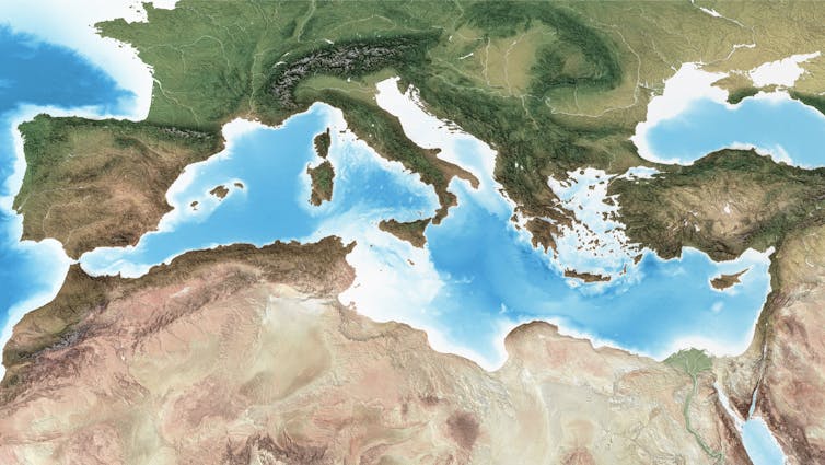
A little over 5 million years ago, water from the Atlantic Ocean found a way through the present-day Strait of Gibraltar. According to this theory, oceanic water rushed faster than a speeding car down a kilometre-high slope towards the empty Mediterranean Sea, excavating a skyscraper-deep trough on its way.
The Med was, at the time, a largely dry and salty basin, but so much water poured in that it filled up in just a couple of years – maybe even just a few months. At its peak, the flood discharged about 1,000 times the water of the modern-day Amazon river.
At least, that’s the thesis one of us put forward in a 2009 study of an underwater canyon excavated along the Strait of Gibraltar, which he presumed to have been carved out by this massive flood. If correct, (and some scientists do dispute the theory), the so-called Zanclean megaflood would be the largest single flood recorded on Earth.
But extraordinary claims like this require extraordinarily solid evidence. Our latest research investigates sedimentary rock from the Zanclean era that seems to record how the water surged through a gap between modern-day Sicily and mainland Africa to refill the eastern half of the Mediterranean.
Our finding is the latest twist in a story that began in the late 19th century. That’s when geologists studying salt-rich rock outcrops around the Mediterranean became increasingly aware that something unusual had happened between roughly 5 and 6 million years ago, well before the glaciations of recent ice ages: the sea had dried up. They named that age “Messinian” and the drying up eventually became known as the Messinian salinity crisis.
In the 1970s, scientists for the first time drilled deep below the Mediterranean into sedimentary rocks from the Messinian age. They made three surprising discoveries. First, they found a massive layer of salt – kilometres thick – below much of the seafloor. This confirmed that a vast environmental change had happened about 6 million years ago, just when tectonic plates shifted and the sea became largely isolated from the Atlantic Ocean.
Second, right above this salt layer, they found sediment with fossils from shallow, low-salt lakes. This suggested that the Mediterranean Sea dropped to more than a kilometre below today’s level, and as most of the water evaporated, salt was left behind. A series of lakes would have remained in the lowest parts of the basin, refreshed and kept relatively salt-free by streams. This interpretation was also supported by seismic surveys of the seabed which revealed rivers once cut through a dry landscape.
And third, the rocky layers above the salt abruptly shifted back to more typical deep sea sediment. (We now know that less than 11% of Mediterranean marine species survived the crisis, showing just how big and lasting the impact was on life in the sea). The term Zanclean Flood was coined in the 1970s to refer to the end of the crisis, without scientists really knowing what it consisted of or the timescale taken to refill the dry Mediterranean basin.
Events proposed to have occurred in the Mediterranean between 6 and 5.3 million years ago.
A cataclysmic refill
The next breakthrough came in 2009, when geophysical data for the planned Africa-Europe tunnel through Gibraltar suggested that a huge underwater trench between the Atlantic Ocean and the Mediterranean Sea must have been created by a sudden and cataclysmic flood.
Our latest research backs up this hypothesis. As part of a team led by Maltese seabed scientist Aaron Micallef, we explored the region where the flood water filling the western basin of the Mediterranean should have run into a ridge of higher land connecting modern-day Africa and Italy, known as the Sicily Sill. Was there any evidence, we wondered, of a second megaflood as the eastern Mediterranean filled up?
Piecing together the puzzle
Giovanni Barreca, one of our co-authors on the recent paper, grew up in southern Sicily. He long ago realised that the low hills near the coast are an extension of the Sicily Sill over which the megaflood must have progressed from west to east. The area, he thought, might contain clues.
Our team visited this part of Sicily and noticed that the hills were indeed unusual. Their aligned and streamlined shapes separated by deeply eroded depressions are very similar to streamlined hills in Washington state in the US. Those Washington hills were carved out by a megaflood at the end of the last Ice Age when the vast Lake Missoula dammed up behind a glacier and emptied catastrophically.
If those hills and depressions in Sicily were also shaped by a huge flood, then rock debris eroded from the base of the depressions should be found dumped on top of the hills, more than 5 million years later.
Sure enough, we did find jumbled and contorted rock debris up to boulder size along the crest of the hills. They were the same types of rock found within the depressions as well as further inland.
Remnants of a boulder dumped 5 million years ago on a hilltop near the town of Rosolini, Sicily.Paul Carling
To double check our work, we developed a computer simulation (or “model”) of how flood waters might have crossed one part of the Sicily Sill. It showed that the flood flow would indeed mimic the direction of the streamlined hills.
In fact, the model showed that the hills would have been carved out by water 40 metres or more deep, travelling at 115 kilometres per hour (71mph). In the one area we modelled, 13 million cubic metres of water per second would have flooded into the eastern Mediterranean basin (for reference: the Amazon today is about 200,000 cubic metres per second). Remarkably, this is still only a fraction of the water that first flowed through Gibraltar and then into the eastern Mediterranean basin near Sicily.
¿Qué pasaría si convirtiéramos todo el mar Mediterráneo en una gigantesca salina? ¿Sobreviviría su fauna? ¿Cuánto tiempo necesitaríamos para recuperarla? Parecerían preguntas intrascendentes si no fuera porque un arquitecto bávaro dedicó buena parte de su vida a ese proyecto: construir una gran presa a través del estrecho de Gibraltar y dejar que el Mediterráneo se secara para colonizar el terreno ganado al mar.
Mapa del proyecto Atlantropa de Herman Sörgel, complementario al Lebensraum de la Alemania nazi, que buscaba el vaciado parcial del Mediterráneo para ganar más tierra en Europa.Iraultzailea/Wikimedia Commons, CC BY-SA
Herman Sörgel organizó conferencias y documentales y recaudó financiación hasta los años 50 para un proyecto que, pensó, fomentaría la cooperación entre África y Europa y electrificaría ambos continentes con gigantescos proyectos hidroeléctricos.
Lo que Sörgel no sabía es que su sueño ya había sido realidad cinco millones y medio de años antes, a finales de la era del Mioceno, sin más proyecto detrás que el de las leyes naturales.
Cuando el Mediterráneo se secó
Desde la década de los 70, varias generaciones de geólogos y geofísicos marinos han confirmado la existencia de una capa de sal de entre uno y tres kilómetros de espesor enterrada en la mayor parte del Mediterráneo más profundo.
Se trata de casi un millón de kilómetros cúbicos de sal que atestiguan un breve periodo de aislamiento del Mediterráneo del resto del océano. Breve en el sentido geológico, porque el episodio duró unos 190 000 años. Y no solo eso: el seco clima mediterráneo provocó la evaporación de sus aguas y expuso a la intemperie gran parte de su suelo marino tras la precipitación de toda aquella sal.
Vídeo sobre la crisis de salinidad del Messiniense.
El responsable no fue ningún excéntrico arquitecto alemán sino la tectónica de placas. La cuenca mediterránea, atrapada entre dos continentes que continúan hoy aproximándose hasta dos centímetros cada año, quedó aislada del Atlántico y sus aguas se evaporaron rápidamente debido al clima árido que domina nuestro planeta en estas latitudes.
Cierre del último canal de conexión entre el Mediterráneo y el Atlántico, conduciendo a la desecación completa del primero durante la crisis salina mesiniense hace 5,96 millones de años. (B) y (C): los ríos que anteriormente drenaban al Mediterráneo excavaron en los márgenes continentales profundas gargantas erosivas; (D) la evaporación condujo a la saturación de la sal en las aguas y a la precipitación de capas de sal de más de un kilómetro de espesor; (E) en las partes más profundas del mar quedaron lagos donde se evaporaba el agua recogida de la cuenca mediterránea. La viñeta recrea el tránsito de mamíferos, como camélidos y gerbillos, a través del estrecho de Gibraltar.Pau Bahí y Daniel García Castellanos/Wikimedia Commons, CC BY-SA
Gracias a ello, no es necesario ningún experimento geoingenieril para responder a la pregunta inicial: ¿cómo de resiliente es la vida marina frente a una crisis medioambiental de este calibre?
La respuesta acaba de ser publicada en la revista Science, en un estudio liderado por Konstantina Agiadi, de la Universidad de Vienna, con la colaboración del CSIC y de 25 paleontólogos de 25 institutos europeos. Tras reunir toda la información fósil del Mediterráneo de entre hace 11 y 2 millones de años, nuestros resultados sugieren que la vida marina autóctona fue prácticamente extinguida durante el aislamiento del Mediterráneo y que la posterior recolonización por especies atlánticas dio origen a la fauna mediterránea tal y como la conocemos hoy en día.
Las especies autóctonas, las desaparecidas y las inmigrantes
Analizando estadísticamente la información de más de 750 artículos científicos hemos podido documentar 22 932 muestras de vida marina fósil que documentan 4 897 especies mediterráneas antes de la salinización del Mediterráneo. De las 779 especies posiblemente endémicas (encontradas solo en el Mediterráneo), solo 86 seguían presentes después del fenómeno salino.
A modo de ejemplo, todos los corales tropicales que abundaban en el Mediterráneo antes del gigantesco cambio medioambiental desaparecieron. En cambio, alguna especie de sardina aparentemente endémica logró sobrevivir. Un ejemplo de mamífero superviviente es el sirenio, emparentado con los actuales manatíes y dugongos (también conocidos como vacas marinas).
Reconstrucción de un paisaje marino del Plioceno temprano (hace 5,1-4,5 millones de años) frente a la costa de Toscana (Italia) en la que aparecen el monodóntido Casatia thermophila y el sirenio Metaxytherium subapenninum, dos de las muchas especies que sólo se encontraron en el mar Mediterráneo tras la reapertura de la puerta al Atlántico.Alberto Gennari, CC BY
Debido a lo limitado y fragmentado del registro fósil, no podemos asegurar que estas especies fueran todas endémicas ni que no hubieran sobrevivido fuera del Mediterráneo, de ahí el valor de realizar este estudio de forma estadística con un gran número de especies. Pero las que lo eran, ¿dónde consiguieron sobrevivir? ¿Qué refugios encontraron para evitar el radical aumento de salinidad y temperatura?
Estas preguntas siguen sin respuesta, pero sí hemos podido constatar que los cambios de las poblaciones son debidos al reemplazo por especies atlánticas tras la reinundación, más que a una rápida adaptación al nuevo medio hipersalino. Es decir, la vida no tuvo tiempo para adaptarse y las especies extintas fueron sustituidas por otras exóticas, atlánticas.
Algunas especies icónicas como el gran tiburón blanco y el delfín aparecieron por primera vez en el Mediterráneo solo tras la crisis. Y aún más interesante: la actual mayor riqueza faunística del Mediterráneo occidental se estableció tras la reinundación, mientras que anteriormente el número de especies era mayor en el Mediterráneo oriental (mar Jónico y mar de Levante).
El delfín listado (Stenella coeruleoalba) es una de las especies de delfines más frecuentes del Mediterráneo. Los delfines aparecieron en este mar al restablecerse las condiciones marinas normales tras la crisis salina.Francesca Grossi/Wikimedia Commons, CC BY
Lecciones sobre las extinciones masivas
El impacto del aislamiento del Mediterráneo sobre su fauna y flora fue enorme, destruyendo la mayoría de sus ecosistemas y su conectividad. Otro importante resultado que hemos obtenido estudiando aquel gigantesco experimento natural es que la recuperación en términos de número de especies duró más de 1,7 millones de años. Esta lenta recuperación de la riqueza de los ecosistemas mediterráneos proporciona la primera cuantificación detallada de la respuesta biológica estadística a un evento de extinción de esta magnitud.
La biodiversidad mediterránea actual es muy alta gracias a la presencia de numerosas especies endémicas. Nuestros resultados sugieren que esto también era así hace 6 millones de años, pero que la gran mayoría de esas especies endémicas desaparecieron durante el aislamiento y salinización del Mediterráneo.
Y quizá otra lección aprendida de este estudio sea que, por muy tentadores proyectos de geoingeniería que se nos ocurran y nos permitan soñar con mantener el actual ritmo de emisiones y de destrucción de ecosistemas, vale la pena aprovechar bien las experiencias que nos brinda el pasado geológico de la Tierra antes que experimentar con ella. El Mediterráneo, pese a mantener el océano global como reservorio de especies, tardó millones de años en recuperarse. Nadie sabe aún cuánto tardará en recuperarse la vida marina de un cambio a escala global como el que está en curso.
A little over 5 million years ago, water from the Atlantic Ocean found a way through the present-day Strait of Gibraltar. According to this theory, oceanic water rushed faster than a speeding car down a kilometre-high slope towards the empty Mediterranean Sea, excavating a skyscraper-deep trough on its way.
The Med was, at the time, a largely dry and salty basin, but so much water poured in that it filled up in just a couple of years – maybe even just a few months. At its peak, the flood discharged about 1,000 times the water of the modern-day Amazon river.
At least, that’s the thesis one of us put forward in a 2009 study of an underwater canyon excavated along the Strait of Gibraltar, which he presumed to have been carved out by this massive flood. If correct, (and some scientists do dispute the theory), the so-called Zanclean megaflood would be the largest single flood recorded on Earth.
But extraordinary claims like this require extraordinarily solid evidence. Our latest research investigates sedimentary rock from the Zanclean era that seems to record how the water surged through a gap between modern-day Sicily and mainland Africa to refill the eastern half of the Mediterranean.
Our finding is the latest twist in a story that began in the late 19th century. That’s when geologists studying salt-rich rock outcrops around the Mediterranean became increasingly aware that something unusual had happened between roughly 5 and 6 million years ago, well before the glaciations of recent ice ages: the sea had dried up. They named that age “Messinian” and the drying up eventually became known as the Messinian salinity crisis.
In the 1970s, scientists for the first time drilled deep below the Mediterranean into sedimentary rocks from the Messinian age. They made three surprising discoveries. First, they found a massive layer of salt – kilometres thick – below much of the seafloor. This confirmed that a vast environmental change had happened about 6 million years ago, just when tectonic plates shifted and the sea became largely isolated from the Atlantic Ocean.
Second, right above this salt layer, they found sediment with fossils from shallow, low-salt lakes. This suggested that the Mediterranean Sea dropped to more than a kilometre below today’s level, and as most of the water evaporated, salt was left behind. A series of lakes would have remained in the lowest parts of the basin, refreshed and kept relatively salt-free by streams. This interpretation was also supported by seismic surveys of the seabed which revealed rivers once cut through a dry landscape.
And third, the rocky layers above the salt abruptly shifted back to more typical deep sea sediment. (We now know that less than 11% of Mediterranean marine species survived the crisis, showing just how big and lasting the impact was on life in the sea). The term Zanclean Flood was coined in the 1970s to refer to the end of the crisis, without scientists really knowing what it consisted of or the timescale taken to refill the dry Mediterranean basin.
Events proposed to have occurred in the Mediterranean between 6 and 5.3 million years ago.
A cataclysmic refill
The next breakthrough came in 2009, when geophysical data for the planned Africa-Europe tunnel through Gibraltar suggested that a huge underwater trench between the Atlantic Ocean and the Mediterranean Sea must have been created by a sudden and cataclysmic flood.
Our latest research backs up this hypothesis. As part of a team led by Maltese seabed scientist Aaron Micallef, we explored the region where the flood water filling the western basin of the Mediterranean should have run into a ridge of higher land connecting modern-day Africa and Italy, known as the Sicily Sill. Was there any evidence, we wondered, of a second megaflood as the eastern Mediterranean filled up?
Piecing together the puzzle
Giovanni Barreca, one of our co-authors on the recent paper, grew up in southern Sicily. He long ago realised that the low hills near the coast are an extension of the Sicily Sill over which the megaflood must have progressed from west to east. The area, he thought, might contain clues.
Our team visited this part of Sicily and noticed that the hills were indeed unusual. Their aligned and streamlined shapes separated by deeply eroded depressions are very similar to streamlined hills in Washington state in the US. Those Washington hills were carved out by a megaflood at the end of the last Ice Age when the vast Lake Missoula dammed up behind a glacier and emptied catastrophically.
If those hills and depressions in Sicily were also shaped by a huge flood, then rock debris eroded from the base of the depressions should be found dumped on top of the hills, more than 5 million years later.
Sure enough, we did find jumbled and contorted rock debris up to boulder size along the crest of the hills. They were the same types of rock found within the depressions as well as further inland.
Remnants of a boulder dumped 5 million years ago on a hilltop near the town of Rosolini, Sicily.Paul Carling
To double check our work, we developed a computer simulation (or “model”) of how flood waters might have crossed one part of the Sicily Sill. It showed that the flood flow would indeed mimic the direction of the streamlined hills.
In fact, the model showed that the hills would have been carved out by water 40 metres or more deep, travelling at 115 kilometres per hour (71mph). In the one area we modelled, 13 million cubic metres of water per second would have flooded into the eastern Mediterranean basin (for reference: the Amazon today is about 200,000 cubic metres per second). Remarkably, this is still only a fraction of the water that first flowed through Gibraltar and then into the eastern Mediterranean basin near Sicily.
[ICTJA-CSIC's Press Note on our own research (see open access article linked at the foot of this page)]
A study conducted by an international team of scientists has found new evidence supporting the hypothesis of a mega-flood occurring during the Zanclean period, in which water from the Atlantic poured back into the Mediterranean sea and ended the Messinian Salinity Crisis (MSC) 5 million years ago. The study, led by Professor Aaron Micallef from the University of Malta, has been published in the Scientific Reports journal.
Recreation of the evolution of the Messinian salinity crisis, between 6 and 5.3 milion years ago. This is one of the scenarios competing among the scientific community studying this period. Time scale (milion years per second) not to scale. [Credit: Univ. of Malta]
Using seismic profiles and borehole data from offshore eastern Sicily, researchers have identified a large body of sediments buried in the subsurface of Sicily Channel which are characterized as being "extensive" and "chaotic." They have named this mass of material Unit 2.
The study says that this huge mass of sediments is composed of materials eroded and transported by the great flow of water that flooded the Ionian Basin through the Strait of Sicily once the western basin of the Mediterranean was refilled with the contribution of water coming from the Atlantic Ocean that had poured in previously through the Strait of Gibraltar. This event is known as Zanclean megaflood.
Location and geometry of the "Unit 2" corresponding to the sediment body originated by the Zanclean megaflood. Source: Aaron Micallef (University of Malta)
The discovered sediments have been located over a layer of salts originated previously during the partial desiccation of the Mediterranean Sea during the MSC and under another layer of common marine sediments that were deposited after the flood and during the restoration of the normal marine conditions.
"The deposits identified in our study have little reflectivity of the seismic waves, they are seismically transparent, and present a disordered internal structure of the layers which is very similar to the sediments typically originated in catastrophic floods," explains Daniel García-Castellanos, co-author of the study and researcher from Barcelona's Institute of Earth Sciences Jaume Almera of the CSIC (ICTJA-CSIC).
The study indicates that the sedimentary body found next to the base of the Malta Escarpment, between the eastern and western Mediterranean Sea, is wedge-shaped, and its estimated thickness is up to 860 meters in some parts. According to the researchers, it would be the largest known megaflood deposit on Earth.
"According to the models of the paper that we published in Nature in 2009, the flood would have lasted only a few years, reaching discharges of up to 100 million cubic meters per second, about a rate thousand times the current flow of the Amazon River," adds García-Castellanos.
Researchers have also identified a spot in the channel of Sicily as the most likely gateway for the eastern Mediterranean Zanclean flood across the Malta escarpment, the submarine canyon of Noto (southeast Sicily). The authors of the study explain that this canyon has a unique morphology—its amphitheatre-shaped head is 6 km wide and is "similar to that of bedrock canyons rapidly eroded by megafloods. "The researchers interpret the Noto submarine canyon as the collector of the cascading flow into the Ionian Basin.
The study points to the abrupt and catastrophic nature of the environmental changes that occurred during the Messinian period, the most important since the dinosaurs' extinction 65 million years ago," says Daniel García-Castellanos.
The Messinian Salinity Crisis: an unrecognizable Mediterranean Sea
About 6 million years ago, the connection between the Atlantic Ocean and the Mediterranean Sea was interrupted. This event led to the partial desiccation of the Mediterranean Sea, which became a giant saline lake, with an estimated sea-level drawdown of 1300-2400 meters. This event is known as Messinian Salinity Crisis (MSC).
A major open question about this period is how normal marine conditions were restored. The hypothesis of the Zanclean megaflood proposes that there was a massive inflow of water through the Strait of Gibraltar that first flooded the western Mediterranean Basin. Then, through the Strait of Sicily, which was once the division between the eastern and western basins, flooded the Ionian Basin. Some studies indicate that this filling process lasted between a few months and two years.
Micallef, A., et al. (2018), Evidence of the Zanclean megaflood in the eastern Mediterranean Basin, Scientific Reports, 8(1), 1078, DOI: 10.1038/s41598-018-19446-3
Artistic interpretation of the proposed lowstand
of the Mediterranean level during the salinity
crisis. Authors: Pibernat and Garcia-Castellanos
130 years have gone by since the scientific recognition of a hypersaline Mediterranean sea around 6 million years ago;
50 years have passed since documenting widespread submarine and riverine erosional features that suggest a subaerial exposure of parts of the Mediterranean Sea;
We are 40 years after the first abissal drilling reaching the top of a salt layer thicker than 1 kilometer...
And yet, the most intriguing and debated question around the Messinian salinity crisis remains whether there was a large sea level fall during the crisis, more than a few hundreds of meters, perhaps more than a kilometer. Evidence in favor and against is piling up on the desks of geoscientists.
We now publish a new piece of evidence that supports a Yes answer to this long-standing question. A fall in the level of the Mediterranean Sea about 6 million years ago may have increased volcanic activity over the entire region (Sternai et al., 2017, Nature Geosc.).
Geoscientists inspecting the Realmonte mine in Sicily,
where Messinian salt is commercialized.
A layer ranging from 1 to 2 km of salt (halite) spreads below much of the Mediterranean seabed, formed when the Mediterranean Sea became isolated from the Atlantic Ocean about 6.0 to 5.3 million years ago, leading to evaporation and sea-level fall in an event known as the Messinian salinity crisis. The rate and amount of sea-level fall in the Mediterranean during this time is strongly debated. However, if the sea-level drop was dramatic and rapid, it could have unloaded the Earth’s surface, decompressing the mantle below. Such mantle decompression can enhance magma production and, in turn, lead to more frequent volcanic eruptions at the surface.
Pietro Sternai and the rest of us test this idea using a combination of geological data and numerical modelling. Dated magma intrusions and volcanic eruptions in the region show that there was a pulse of increased volcanic activity towards the end of the Messinian salinity crisis. By calculating changes in the surface load caused by a kilometre-scale drop in sea level, and taking into account the counter weight of the increased density of the remaining highly saline water and accumulating salt deposits we verify that such changes in sea level are sufficient to unload and decompress the mantle, triggering a significant increase in volcanism over the Mediterranean.
Decompression and vertical rebound of the lithosphere
in response to a sudden evaporation of the sea.
The results provide independent support for the idea that sea-level fall during the Messinian salinity crisis was rapid and occurred on a dramatic scale, and also highlights the sensitivity of Earth’s solid interior to changes at the surface.
Check also the News & Views article by Jean-Arthur Olive: “This proposed link will motivate the collection of high-resolution field data that better constrain the timing of volcanism in the Mediterranean, along with the development of novel approaches for coupled lithosphere–magma dynamics.”
Out of this age of crisis, a book has just been published that aims at fully opening the doors of imagination to show how audacious we humans are when in need to restart from scratch:
The book includes an article by the editor Ricarda Vidal (King’s College London) giving an updated perspective on the Atlantropa Project(1929). Atlantropa intended to reduce the area of the Mediterranean Sea by 30% by damming the Strait of Gibraltar, allowing natural evaporation to lower the sea level by a couple of hundred meters. With this project, Herman Sörgel sought to control the inflow of Atlantic seawater to generate electricity, to exposing new inhabitable land (former submarine continental shelf), and to use the Nile River to irrigate a vast part of the Sahara Desert.
The project thus aimed at mimicking what nature did 6 million years ago during the Messinian Salinity Crisis, and that's why I coauthor with Vidal a second chapter dealing with what we know about this ancient salinization and desiccation of the Mediterranean from a scientific perspective, and about the footprint this geology left in western culture.
The rest of the volume discusses fascinating Alternative Worlds including seasteads, planned cities, the high-rise age, and the promising worlds-to-be in the outer space.
Part I: Shaping the Earth and Sea
1. Ricarda Vidal: Atlantropa: One of the Missed Opportunities of the Future
2. Daniel Garcia-Castellanos/Ricarda Vidal: Alternative Mediterraneans Six Million Years Ago: A Model for the Future?
3. Philip E. Steinberg/Elizabeth A. Nyman/Mauro J. Caraccioli: Atlas Swam: Freedom, Capital and Floating Sovereignties in the Seasteading Vision
Part II: The 1960s – Building the Future
4. Patricia Silva McNeill: The Last ‘City of the Future’: Brasília and its Representation in Literature and Film
5. Elena Solomides: The Post-War High-Rise: Promise of an Alternative World
6. Christopher Daley: ‘The landscape is coded’: Visual Culture and the Alternative Worlds of J.G. Ballard’s Early Fiction
Part II: Alternative Lives
7. Maya Oppenheimer: Designed Surfaces and the Utopics of Rejuvenation
8. Boukje Cnossen: The Alternative World of Michel Houellebecq
9. Susanne Kord: From the American Myth to the American Dream: Alternative Worlds in Recent Hollywood Westerns
10. Marjolaine Ryley: Growing up in the New Age: A Journey into Wonderland?
Part IV: Outer Space
11. Peter Dickens: Alternative Worlds in the Cosmos
12. Ingo Cornils: Between Bauhaus and Bügeleisen: The Iconic Style of Raumpatrouille (1966)
13. Rachel Steward: Blue Sky Thinking in a Post-Astronautic Present.
Alternative Worlds, Blue-Sky thinking since 1900, R. Vidal & Cornils (Peter Lang Publishing, Bern, ISSN 3034317875, 9783034317870).
R.B. Cathcart, "What if We Lowered the Mediterranean Sea?", Speculations in Science and Technology, 8: 7-15 (1985).
[Este post está orientado a estudiantes que comienzan una carrera universitaria en ciencias, no necesariamente geología]
El Mar Mediterráneo es lo que resta en la actualidad del antiguo Océano de Tethys, que quedó atrapado entre las placas tectónicas de África y Eurasia durante su lenta aproximación en los últimos 65 millones de años. A causa de esta aproximación,la corteza terrestre oceánica que alojaba al Océano de Tethys fue obligada a hundirse (a subducir) en el manto terrestre, bajo Eurasia, tras lo cual se produjo la colisión entre ambos continentes, formando los Pirineos, los Alpes y las Montañas de Zagros (orogenia Alpina). Fue así como quedaron desconectados el actual Mar Mediterráneo y el Océano Índico hace unos 15 millones de años. Sólo en el Mediterráneo Oriental quedan restos de aquella corteza de Tethys que aún no han subducido y que de hecho constituyen la corteza oceánica más antigua preservada en el planeta: unos 270 millones de años de edad. Puedes descargar este espectacular KML para Google Earth y visualizar la edad de formación de la corteza terrestre.
Fig. 1. Movimiento de las placas tectónicas deducido principalmente a partir del campo magnético grabado en las rocas (técnica conocida como paleomagnetismo) y de la geología y paleontología observadas en superficie.
Fig. 2. Movimiento de rotación de África respecto a Eurasia en los últimos 190 Millones de años. A partir de medidas de paleomagnetismo en rocas. Vía MantlePlumes.org
Es sorprendente encontrar la corteza oceánica más antigua del planeta en el Mediterráneo, pues el acercamiento entre Europa y África continúa hoy a un ritmo geológicamente rápido, de unos 4 milímetros por año en la región más occidental (entre España y Marruecos), y a velocidades aún mayores y con mayor actividad sísmica en Grecia o Turquía.
Fig. 3. Movimiento relativo de Anatolia y el este del Mediterráneo respecto a Eurasia, obtenido a partir de medidas de GPS de alta precisión. La longitud de las flechas indica la velocidadactual debido a la tectónica medida en una estación de GPS. Las mayores corresponden a 4 cm/año.
Fig. 4. Modelo de la velocidad tectónica en el Mediterráneo (flechas
relativas a Eurasia) y de las tasas de deformación que implican.
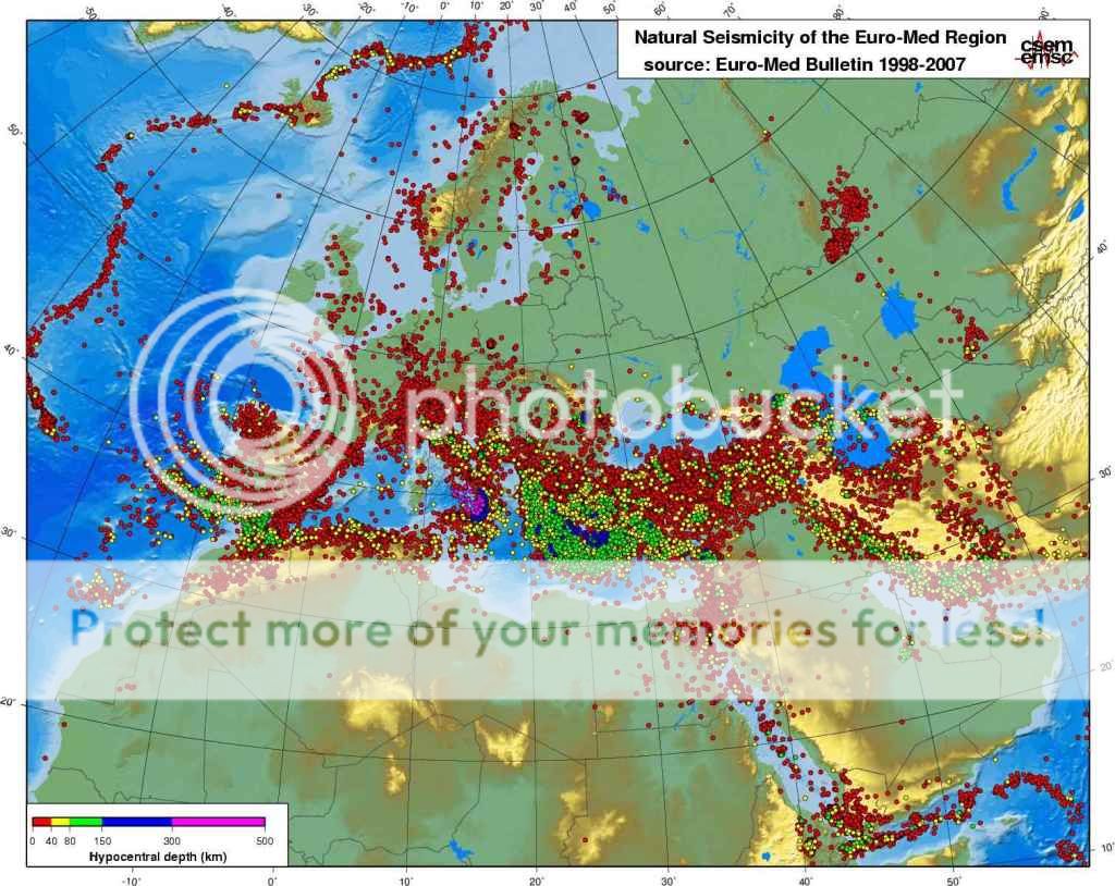
Pero el Mar Mediterráneo ha tenido una evolución tectónica más compleja que la simple subducción de África bajo Eurasia, como reflejan la heterogénea distribución de los terremotos (Fig. 5) y los varios dominios o subplacas cuyos movimientos tectónicos responden de manera poco intuitiva al acercamiento entre los dos continentes (Fig. 6b).
Fig. 5. Distribución de terremotos y su profundidad en el área mediterránea.
Como consecuencia de la geometría heredada de ambos continentes, se han formado varias zonas de subducción diferenciadas (Fig. 6b) en las que la corteza oceánica de Tethys es cabalgada por los márgenes del sur de Europa antes de sumergirse en el manto terrestre. Un ejemplo es la subducción que se produce en el Arco de Calabria (Sicilia y sur de Italia), donde la placa Africana subduce bajo el Mar Tirreno, dando origen a una importante actividad sísmica y volcánica (Etna, Stromboli, etc, Fig. 6c).
Fig. 6a. Esquema del proceso de subducción
de las placas tectónicas oceánicas.
Fig. 6c. Hundimiento y retroceso del slab
(de la porción de placa tectónica subducida)
de Tethys dando lugar a la formación por
extensión de la corteza del Mar Mediterráneo
(Mar Tirreno en la imagen). África a la derecha; Europa a la Izda. De Faccenna et al., GJI, 2001)
Fig. 6b. Mapa tectónico simplificado del Mediterráneo actual, mostrando la edad de formación de la nueva corteza oceánica (azul, de hasta 25 millones de años) tras la subducción del Tethys en la parte occidental. Las zonas mucho más antiguas de corteza oceánica en la zona oriental (morado) corresponden a la placa del antiguo océano de Tethys. Las líneas dentadas rojas indican las fosas donde esa placa se adentra en el manto (subduce) bajo Europa.
Para entender la formación del Mediterráneo es clave comprender un proceso llamado extensión de tras-arco (back-arc extension), que es el estiramiento o extensión de la corteza terrestre que ocurre detrás de una zona de subducción, encima del slab subducido (a la izda. en el corte de la Fig. 6c). Debido a la mayor densidad de la placa de Tethys, ésta se hundió en el manto succionando y estirando la placa bajo la cual subducía (Europa). A consecuencia de esa dinámica (Fig. 7) se separaron del continente europeo las islas de Córcega, Cerdeña y Baleares.Otro ejemplo más lejano del mismo proceso es la separación que actualmente se produce entre Japón y Asia, debida a la subducción de la placa Pacífica bajo la fosa donde se originó el terremoto de Sendai.
Fig. 7. Izda.: la extensión de tras-arco es un estiramiento de la corteza que se produce encima de los slabs subducidos. Vídeo: Simulación de la extensión de tras-arco (back-arc extension) debida al hundimiento y la retirada de una placa tectónica (slab retreat orslab rollback), modelo de Moresi y coautores. Si el lado izquierdo fuera África y el derecho Europa (al revés en el esquema de la izda.), entonces la extensión que se produce en el centro correspondería al Mediterráneo.
Fig. 8. Reconstrucción de la retirada del slab (slab retreat) que da lugar a la extensión del Mar Tirreno y del Golfo de Valencia, separando las islas Baleares de la Península Ibérica, hace unos 25 millones de años. Las líneas discontinuas indican la posición de la subducción hace 30 y 16 millones de años. Las flechas negras indican también el mismo proceso ocurrido en el arco helénico (Grecia) y en la Cuenca Panónica (Hungría/Rumanía).
En resumen: hoy el Mediterráneo occidental ocupa una enorme cuenca extensiva de tras-arco desgarrada tras la subducción de la corteza oceánica de Tethys bajo el continente europeo y la posterior colisión continental entre África y Eurasia. Esta es al menos la visión más generalizada hoy entre los geólogos.